Weather Alert in Minnesota
Winter Storm Warning issued April 3 at 2:23AM CDT until April 4 at 10:00PM CDT by NWS Twin Cities/Chanhassen MN
AREAS AFFECTED: Todd; Morrison
DESCRIPTION: ...MIXED WINTER EVENT WITH SNOW, SLEET, AND ICE ACCUMULATION FRIDAY INTO SATURDAY... .A mixed precipitation event will unfold across Minnesota into Wisconsin today into tomorrow. Across parts of central Minnesota this will mainly fall as snow with up to 7 inches possible. Farther south a band of freezing rain and sleet from southwest Minnesota to northwest Wisconsin will see ice accumulations up to two tenths of an inch. There will be a sharp cutoff in these ice accumulations, as this will be very sensitive to where the freezing line sets up. So additional shifts in the southward extent maybe needed later in the day. * WHAT...Heavy mixed precipitation expected. Total snow accumulations between 4 and 7 inches, sleet accumulations up to one tenth of an inch, and ice accumulations up to one tenth of an inch. * WHERE...Morrison and Todd Counties. * WHEN...From 4 PM this afternoon to 10 PM CDT Saturday. * IMPACTS...Travel could be very difficult. The hazardous conditions will impact the Friday evening commute.
INSTRUCTION: If you must travel, keep an extra flashlight, food, and water in your vehicle in case of an emergency. Call 5 1 1 or visit 511mn.org for road conditions.
Want more detail? Get the Complete 7 Day and Night Detailed Forecast!
Current U.S. National Radar--Current
The Current National Weather Radar is shown below with a UTC Time (subtract 5 hours from UTC to get Eastern Time).

National Weather Forecast--Current
The Current National Weather Forecast and National Weather Map are shown below.

National Weather Forecast for Tomorrow
Tomorrow National Weather Forecast and Tomorrow National Weather Map are show below.

North America Water Vapor (Moisture)
This map shows recent moisture content over North America. Bright and colored areas show high moisture (ie, clouds); brown indicates very little moisture present; black indicates no moisture.

Weather Topic: What are Fractus Clouds?
Home - Education - Cloud Types - Fractus Clouds
 Next Topic: Freezing Rain
A fractus cloud (scud) is a fragmented, tattered cloud which has
likely been sheared off of another cloud. They are accessory clouds, meaning they
develop from parent clouds, and are named in a way which describes the original
cloud which contained them.
Fractus clouds which have originated from cumulus clouds are referred to as
cumulus fractus, while fractus clouds which have originated from stratus clouds
are referred to as stratus fractus. Under certain conditions a fractus cloud might
merge with another cloud, or develop into a cumulus cloud, but usually a
fractus cloud seen by itself will dissipate rapidly.
They are often observed on the leading and trailing edges of storm clouds,
and are a display of wind activity.
Next Topic: Freezing Rain
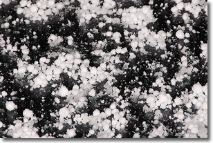
Weather Topic: What is Graupel?
Home - Education - Precipitation - Graupel
 Next Topic: Hail
Graupel is a form of precipitation that is created by atmospheric conditions
which cause supercooled water droplets to contact snow crystals and freeze to
their surface.
Sometimes known as soft hail or snow pellets, graupel is delicate and easily
destroyed by touch. Whereas hail usually falls during severe weather, graupel
doesn't require such conditions to form, and can form in mild precipitation
similar to situations which produce snowfall.
Next Topic: Hail
Current conditions powered by WeatherAPI.com


