Weather Alert in New Mexico
Wind Advisory issued February 16 at 11:52AM MST until February 17 at 10:00PM MST by NWS Midland/Odessa TX
AREAS AFFECTED: Southern Lea County; Van Horn and Highway 54 Corridor; Davis Mountains Foothills
DESCRIPTION: * WHAT...For the Blowing Dust Advisory, visibility between one-quarter and one mile in blowing dust expected. For the Wind Advisory, southwest winds 25 to 35 mph with gusts up to 55 mph expected. * WHERE...In New Mexico, Southern Lea County. In Texas, Davis Mountains Foothills and Van Horn and Highway 54 Corridor. * WHEN...From 5 AM MST /6 AM CST/ to 10 PM MST /11 PM CST/ Tuesday. * IMPACTS...Hazardous driving conditions due to reduced visibility. A sudden gust of wind could drop visibility to near zero instantly. Gusty winds may blow around unsecured objects.
INSTRUCTION: Slow down, use low-beam headlights, and leave plenty of distance between you and other vehicles. Winds this strong can make driving difficult, especially for high profile vehicles. Use extra caution and keep both hands on the steering wheel. Use caution when driving as blowing dust may reduce visibility.
Want more detail? Get the Complete 7 Day and Night Detailed Forecast!
Current U.S. National Radar--Current
The Current National Weather Radar is shown below with a UTC Time (subtract 5 hours from UTC to get Eastern Time).

National Weather Forecast--Current
The Current National Weather Forecast and National Weather Map are shown below.

National Weather Forecast for Tomorrow
Tomorrow National Weather Forecast and Tomorrow National Weather Map are show below.

North America Water Vapor (Moisture)
This map shows recent moisture content over North America. Bright and colored areas show high moisture (ie, clouds); brown indicates very little moisture present; black indicates no moisture.

Weather Topic: What is Precipitation?
Home - Education - Precipitation - Precipitation
 Next Topic: Rain
Precipitation can refer to many different forms of water that
may fall from clouds. Precipitation occurs after a cloud has become saturated to
the point where its water particles are more dense than the air below the cloud.
In most cases, precipitation will reach the ground, but it is not uncommon for
precipitation to evaporate before it reaches the earth's surface.
When precipitation evaporates before it contacts the ground it is called Virga.
Graupel, hail, sleet, rain, drizzle, and snow are forms of precipitation, but fog
and mist are not considered precipitation because the water vapor which
constitutes them isn't dense enough to fall to the ground.
Next Topic: Rain
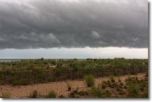
Weather Topic: What are Shelf Clouds?
Home - Education - Cloud Types - Shelf Clouds
 Next Topic: Sleet
A shelf cloud is similar to a wall cloud, but forms at the front
of a storm cloud, instead of at the rear, where wall clouds form.
A shelf cloud is caused by a series of events set into motion by the advancing
storm; first, cool air settles along the ground where precipitation has just fallen.
As the cool air is brought in, the warmer air is displaced, and rises above it,
because it is less dense. When the warmer air reaches the bottom of the storm cloud,
it begins to cool again, and the resulting condensation is a visible shelf cloud.
Next Topic: Sleet
Current conditions powered by WeatherAPI.com


