Weather Alert in Alaska
Winter Weather Advisory issued February 12 at 2:48PM AKST until February 14 at 9:00AM AKST by NWS Anchorage AK
AREAS AFFECTED: Bristol Bay Borough (Naknek and King Salmon); Northern Bristol Bay Coast; Inland Bristol Bay; Lake Iliamna / Nila Vena / Nanvarpak
DESCRIPTION: * WHAT...A wintry mix is expected Friday and into Saturday with snow eventually becoming rain. * WHERE...Bristol Bay Borough (Naknek and King Salmon), Inland Bristol Bay, Lake Iliamna / Nila Vena / Nanvarpak, and Northern Bristol Bay Coast. * WHEN...From 9 AM Friday to 9 AM AKST Saturday. * IMPACTS...Snow becoming rain could make travel very difficult. * ADDITIONAL DETAILS...A complex weather system will move through the region Friday and into Saturday. Early Friday afternoon, snow will move inland from the coast and expand quickly over the region. Snowfall amounts will range from 2 to 4 inches, though localized 6 inch amounts are possible. Late Friday afternoon and early evening will see a lull in snow showers. Shortly after midnight, rain and snow will transition to all rain before sunrise. All rain showers should exit the region before sunrise Saturday morning.
INSTRUCTION: Use caution if travel is necessary.
Want more detail? Get the Complete 7 Day and Night Detailed Forecast!
Current U.S. National Radar--Current
The Current National Weather Radar is shown below with a UTC Time (subtract 5 hours from UTC to get Eastern Time).

National Weather Forecast--Current
The Current National Weather Forecast and National Weather Map are shown below.

National Weather Forecast for Tomorrow
Tomorrow National Weather Forecast and Tomorrow National Weather Map are show below.

North America Water Vapor (Moisture)
This map shows recent moisture content over North America. Bright and colored areas show high moisture (ie, clouds); brown indicates very little moisture present; black indicates no moisture.

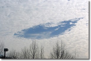
Weather Topic: What are Hole Punch Clouds?
Home - Education - Cloud Types - Hole Punch Clouds
 Next Topic: Mammatus Clouds
A hole punch cloud is an unusual occurrence when a disk-shaped
hole appears in a cirrostratus, cirrocumulus, or altocumulus cloud.
When part of the cloud forms ice crystals, water droplets in the surrounding area
of the cloud evaporate. The effect of this process produces a large elliptical
gap in the cloud. The hole punch cloud formation is rare, but it is not specific
to any geographic area.
Other names which have been used to describe this phenomena include fallstreak hole,
skypunch, and cloud hole.
Next Topic: Mammatus Clouds
Weather Topic: What are Nimbostratus Clouds?
Home - Education - Cloud Types - Nimbostratus Clouds
 Next Topic: Precipitation
A nimbostratus cloud is similar to a stratus cloud in its formless,
smooth appearance. However, a nimbostratus cloud is darker than a stratus cloud,
because it is thicker.
Unlike a stratus cloud, a nimbostratus cloud typically brings with it the threat
of moderate to heavy precipitation. In some cases, the precipitation may evaporate
before reaching the ground, a phenomenon known as virga.
Next Topic: Precipitation
Current conditions powered by WeatherAPI.com


