Weather Alert in Kansas
Fire Weather Watch issued February 15 at 12:27PM CST until February 17 at 8:00PM CST by NWS Dodge City KS
AREAS AFFECTED: Trego; Scott; Lane; Ness; Hamilton; Kearny; Finney; Hodgeman; Stanton; Grant; Haskell; Gray; Ford; Morton; Stevens; Seward; Meade; Clark
DESCRIPTION: * AFFECTED AREA...Fire Weather Zone 030 Trego, Fire Weather Zone 043 Scott, Fire Weather Zone 044 Lane, Fire Weather Zone 045 Ness, Fire Weather Zone 061 Hamilton, Fire Weather Zone 062 Kearny, Fire Weather Zone 063 Finney, Fire Weather Zone 064 Hodgeman, Fire Weather Zone 074 Stanton, Fire Weather Zone 075 Grant, Fire Weather Zone 076 Haskell, Fire Weather Zone 077 Gray, Fire Weather Zone 078 Ford, Fire Weather Zone 084 Morton, Fire Weather Zone 085 Stevens, Fire Weather Zone 086 Seward, Fire Weather Zone 087 Meade and Fire Weather Zone 088 Clark. * TIMING...From Tuesday afternoon through Tuesday evening. * WINDS...Southwest 30 to 40 mph with gusts up to 65 mph. * RELATIVE HUMIDITY...As low as 15 percent. * IMPACTS...Any fire that develops will catch and spread quickly. Outdoor burning is not recommended.
INSTRUCTION: A Fire Weather Watch means that critical fire weather conditions are forecast to occur. Listen for later forecasts and possible Red Flag Warnings.
Want more detail? Get the Complete 7 Day and Night Detailed Forecast!
Current U.S. National Radar--Current
The Current National Weather Radar is shown below with a UTC Time (subtract 5 hours from UTC to get Eastern Time).

National Weather Forecast--Current
The Current National Weather Forecast and National Weather Map are shown below.

National Weather Forecast for Tomorrow
Tomorrow National Weather Forecast and Tomorrow National Weather Map are show below.

North America Water Vapor (Moisture)
This map shows recent moisture content over North America. Bright and colored areas show high moisture (ie, clouds); brown indicates very little moisture present; black indicates no moisture.

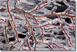
Weather Topic: What is Freezing Rain?
Home - Education - Precipitation - Freezing Rain
 Next Topic: Graupel
Freezing rain is a condition where precipitation which has fallen in the form of
water droplets reaches temperatures which are below freezing and freezes upon
coming into contact
with surface objects. The result of this precipitation is a glaze of ice which
can be damaging to plants and man-made structures. A severe onset of freezing
rain which results in a very thick glaze of ice is known as an ice storm.
Next Topic: Graupel
Weather Topic: What is Hail?
Home - Education - Precipitation - Hail
 Next Topic: Hole Punch Clouds
Hail is a form of precipitation which is recognized by large solid balls or
clumps of ice. Hail is created by thunderstorm clouds with strong updrafts of wind.
As the hailstones remain in the updraft, ice is deposited onto them until their
weight becomes heavy enough for them to fall to the earth's surface.
Hail storms can cause significant damage to crops, aircrafts, and man-made structures,
despite the fact that the duration is usually less than ten minutes.
Next Topic: Hole Punch Clouds
Current conditions powered by WeatherAPI.com


