Weather Alert in Kentucky
Flood Advisory issued February 20 at 3:34PM EST until February 22 at 5:00AM EST by NWS Jackson KY
AREAS AFFECTED: Estill, KY
DESCRIPTION: ...The National Weather Service in Jackson has issued a Flood Advisory for the following rivers in Kentucky... Kentucky River near Ravenna affecting Estill County. * WHAT...Elevated river levels caused by excessive rainfall are expected. * WHERE...Kentucky River near Ravenna. * WHEN...From this afternoon to early Sunday morning. * ADDITIONAL DETAILS... - At 3:20 PM EST Friday the stage was 17.0 feet. - Forecast...The river is expected to rise to a crest of 18.1 feet early Saturday morning. The river will continue to run high through late Saturday night. - Flood stage is 21.0 feet.
INSTRUCTION: If you encounter a flooded roadway, turn around and find an alternative route. The next statement will be issued Saturday morning at 600 AM EST.
Want more detail? Get the Complete 7 Day and Night Detailed Forecast!
Current U.S. National Radar--Current
The Current National Weather Radar is shown below with a UTC Time (subtract 5 hours from UTC to get Eastern Time).

National Weather Forecast--Current
The Current National Weather Forecast and National Weather Map are shown below.

National Weather Forecast for Tomorrow
Tomorrow National Weather Forecast and Tomorrow National Weather Map are show below.

North America Water Vapor (Moisture)
This map shows recent moisture content over North America. Bright and colored areas show high moisture (ie, clouds); brown indicates very little moisture present; black indicates no moisture.

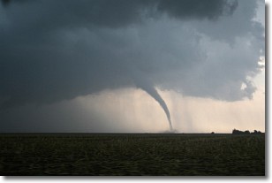
Weather Topic: What are Wall Clouds?
Home - Education - Cloud Types - Wall Clouds
 Next Topic: Altocumulus Clouds
A wall cloud forms underneath the base of a cumulonimbus cloud,
and can be a hotbed for deadly tornadoes.
Wall clouds are formed by air flowing into the cumulonimbus clouds, which can
result in the wall cloud descending from the base of the cumulonimbus cloud, or
rising fractus clouds which join to the base of the storm cloud as the wall cloud
takes shape.
Wall clouds can be very large, and in the Northern Hemisphere they generally
form at the southern edge of cumulonimbus clouds.
Next Topic: Altocumulus Clouds
Weather Topic: What are Altostratus Clouds?
Home - Education - Cloud Types - Altostratus Clouds
 Next Topic: Cirrocumulus Clouds
Altostratus clouds form at mid to high-level altitudes
(between 2 and 7 km) and are created by a warm, stable air mass which causes
water vapor
to condense as it rise through the atmosphere. Usually altostratus clouds are
featureless sheets characterized by a uniform color.
In some cases, wind punching through the cloud formation may give it a waved
appearance, called altostratus undulatus. Altostratus clouds
are commonly seen with other cloud formations accompanying them.
Next Topic: Cirrocumulus Clouds
Current conditions powered by WeatherAPI.com


