Weather Alert in Colorado
High Wind Watch issued February 16 at 5:23AM MST until February 17 at 5:00PM MST by NWS Goodland KS
AREAS AFFECTED: Yuma County; Kit Carson County; Cheyenne County; Cheyenne; Rawlins; Sherman; Thomas; Wallace; Logan; Gove; Greeley; Wichita
DESCRIPTION: * WHAT...WSW to W winds 30 to 40 mph with gusts up to 65 mph possible. * WHERE...Portions of east central and northeast Colorado and northwest and west central Kansas. * WHEN...From Tuesday morning through Tuesday afternoon. * IMPACTS...High winds may move loose debris, damage property and cause power outages. Travel could be difficult, especially for high profile vehicles. Plumes of blowing dust will create pockets of low visibility. Visibilities will likely change rapidly over short distances, making travel hazardous in these areas.
INSTRUCTION: Monitor the latest forecasts for updates and possible warnings. Fasten loose objects or shelter objects in a safe location prior to the onset of winds. Winds this strong can make driving difficult, especially for high profile vehicles. Use extra caution. Blowing dust can significantly lower air quality and it is encouraged that you take preventative measures such as staying indoors or wearing protective breathing masks if outside. High dust concentrations can cause respiratory problems, decrease lung activity, aggravate asthma, and lead to potential heart-related problems, especially with children, the elderly or those with pre-existing respiratory conditions.
Want more detail? Get the Complete 7 Day and Night Detailed Forecast!
Current U.S. National Radar--Current
The Current National Weather Radar is shown below with a UTC Time (subtract 5 hours from UTC to get Eastern Time).

National Weather Forecast--Current
The Current National Weather Forecast and National Weather Map are shown below.

National Weather Forecast for Tomorrow
Tomorrow National Weather Forecast and Tomorrow National Weather Map are show below.

North America Water Vapor (Moisture)
This map shows recent moisture content over North America. Bright and colored areas show high moisture (ie, clouds); brown indicates very little moisture present; black indicates no moisture.

Weather Topic: What are Altostratus Clouds?
Home - Education - Cloud Types - Altostratus Clouds
 Next Topic: Cirrocumulus Clouds
Altostratus clouds form at mid to high-level altitudes
(between 2 and 7 km) and are created by a warm, stable air mass which causes
water vapor
to condense as it rise through the atmosphere. Usually altostratus clouds are
featureless sheets characterized by a uniform color.
In some cases, wind punching through the cloud formation may give it a waved
appearance, called altostratus undulatus. Altostratus clouds
are commonly seen with other cloud formations accompanying them.
Next Topic: Cirrocumulus Clouds
Weather Topic: What are Cirrostratus Clouds?
Home - Education - Cloud Types - Cirrostratus Clouds
 Next Topic: Cirrus Clouds
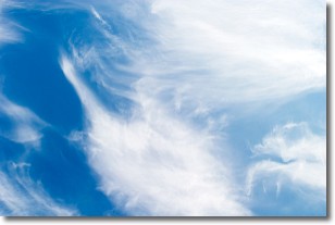
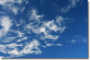
Cirrostratus clouds are high, thin clouds that form above
20,000 feet and are made mostly of ice crystals. They sometimes look like giant
feathers, horse tails, or curls of hair in the sky.
These clouds are pushed by the jet stream and can move at high speeds reaching
100 mph.
What do they indicate?
They indicate that a precipitation is likely within 24 hours.
Next Topic: Cirrus Clouds
Current conditions powered by WeatherAPI.com


