Weather Alert in Oklahoma
Fire Weather Watch issued February 15 at 2:01PM CST until February 17 at 8:00PM CST by NWS Amarillo TX
AREAS AFFECTED: Cimarron; Texas; Beaver; Dallam; Sherman; Hansford; Ochiltree; Lipscomb; Hartley; Moore; Hutchinson; Roberts; Hemphill; Oldham; Potter; Carson; Gray; Wheeler; Deaf Smith; Randall; Armstrong; Donley; Collingsworth; Palo Duro Canyon
DESCRIPTION: * WINDS...Southwest 25 to 35 mph with gusts up to 60 mph. * RELATIVE HUMIDITY...As low as 14 percent. * TEMPERATURES...Around 70. * IMPACTS...Any fires that develop will likely spread rapidly. Outdoor burning is not recommended. * SEVERITY... FUELS (ERC)...70th-89th percentile...4 (out of 5). WEATHER...Critical...3 (out of 5). FIRE ENVIRONMENT...7 (out of 10).
INSTRUCTION: A Fire Weather Watch means that the potential for critical fire weather conditions exists. Listen for later forecasts and possible red flag warnings.
Want more detail? Get the Complete 7 Day and Night Detailed Forecast!
Current U.S. National Radar--Current
The Current National Weather Radar is shown below with a UTC Time (subtract 5 hours from UTC to get Eastern Time).

National Weather Forecast--Current
The Current National Weather Forecast and National Weather Map are shown below.

National Weather Forecast for Tomorrow
Tomorrow National Weather Forecast and Tomorrow National Weather Map are show below.

North America Water Vapor (Moisture)
This map shows recent moisture content over North America. Bright and colored areas show high moisture (ie, clouds); brown indicates very little moisture present; black indicates no moisture.

Weather Topic: What are Cirrus Clouds?
Home - Education - Cloud Types - Cirrus Clouds
 Next Topic: Condensation
Cirrus clouds are high-level clouds that occur above 20,000 feet
and are composed mainly of ice crystals.
They are thin and wispy in appearance.
What do they indicate?
They are often the first sign of an approaching storm.
Next Topic: Condensation
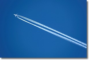
Weather Topic: What are Contrails?
Home - Education - Cloud Types - Contrails
 Next Topic: Cumulonimbus Clouds
A contrail is an artificial cloud, created by the passing of an
aircraft.
Contrails form because water vapor in the exhaust of aircraft engines is suspended
in the air under certain temperatures and humidity conditions. These contrails
are called exhaust contrails.
Another type of contrail can form due to a temporary reduction in air pressure
moving over the plane's surface, causing condensation.
These are called aerodynamic contrails.
When you can see your breath on a cold day, it is also because of condensation.
The reason contrails last longer than the condensation from your breath is
because the water in contrails freezes into ice particles.
Next Topic: Cumulonimbus Clouds
Current conditions powered by WeatherAPI.com


