Weather Alert in Virginia
Flood Warning issued May 14 at 10:37AM EDT until May 16 at 10:40AM EDT by NWS Baltimore MD/Washington DC
AREAS AFFECTED: Clarke, VA; Warren, VA; Jefferson, WV
DESCRIPTION: ...The Flood Warning continues for the following rivers in Maryland...West Virginia...Virginia... North Branch Potomac River Near Cumberland affecting Allegany, Mineral and Hampshire Counties. Potomac River at Harpers Ferry affecting Washington and Jefferson Counties. Shenandoah River at Millville affecting Jefferson, Warren and Clarke Counties. Rapidan River Near Culpeper affecting Culpeper, Orange and Spotsylvania Counties. Opequon Creek near Martinsburg affecting Berkeley and Jefferson Counties. Cacapon River near Great Cacapon affecting Morgan County. Rappahannock River at Fredericksburg affecting Spotsylvania, City of Fredericksburg and Stafford independent cities. ...The Flood Warning is extended for the following rivers in West Virginia...Maryland...Virginia... South Branch Potomac River near Springfield affecting Hardy and Hampshire Counties. Potomac River at Paw Paw affecting Morgan, Allegany and Hampshire Counties. Potomac River at Shepherdstown affecting Berkeley, Washington and Jefferson Counties. Potomac River at Point of Rocks affecting Loudoun and Frederick Counties. Potomac River at Edwards Ferry affecting Montgomery and Loudoun Counties. Rappahannock River at Remington affecting Culpeper and Fauquier Counties. Conococheague Creek at Fairview affecting Washington County. For the South Branch Potomac River...including Franklin, Moorefield - SF, Petersburg, Springfield...Minor flooding is forecast. For the Potomac River...including Paw Paw, Hancock, Shepherdstown, Harpers Ferry, Point of Rocks, Edwards Ferry, Little Falls... Moderate flooding is forecast. For the Shenandoah River...including Millville...Minor flooding is forecast. For the Rappahannock River...including Remington, Fredericksburg, Fredericksburg...Minor flooding is forecast. For the Rapidan River...including Culpeper...Minor flooding is forecast. For the Conococheague Creek...including Fairview...Minor flooding is forecast. For the Opequon Creek...including Martinsburg...Minor flooding is forecast. For the Cacapon River...including Great Cacapon...Minor flooding is forecast. * WHAT...Minor flooding is forecast. * WHERE...Shenandoah River at Millville. * WHEN...From this afternoon to late Friday morning. * IMPACTS...At 12.0 feet, Water reaches the river access at Wagon Trail Place near Harpers Ferry, and completely covers the parking lot of the lower boat ramp at Millville Dam. Portions of the Cool Spring Battlefield begin to flood. * ADDITIONAL DETAILS... - At 9:30 AM EDT Wednesday the stage was 6.0 feet, or 4.0 feet below flood stage. - Forecast...The river is expected to rise above flood stage late this afternoon to a crest of 12.5 feet just after midnight tonight. It will then fall below flood stage early Friday morning. - Flood stage is 10.0 feet. - Flood History...This crest compares to a previous crest of 12.5 feet on 01/02/1976. - Please visit www.weather.gov/safety/flood for flood safety and preparedness information
INSTRUCTION: Motorists should not attempt to drive around barricades or drive cars through flooded areas. Turn around, don't drown when encountering flooded roads. Most flood deaths occur in vehicles. Additional information is available at www.weather.gov/washington or www.weather.gov/baltimore. The next statement will be issued this evening at 730 PM EDT.
Want more detail? Get the Complete 7 Day and Night Detailed Forecast!
Current U.S. National Radar--Current
The Current National Weather Radar is shown below with a UTC Time (subtract 5 hours from UTC to get Eastern Time).

National Weather Forecast--Current
The Current National Weather Forecast and National Weather Map are shown below.

National Weather Forecast for Tomorrow
Tomorrow National Weather Forecast and Tomorrow National Weather Map are show below.

North America Water Vapor (Moisture)
This map shows recent moisture content over North America. Bright and colored areas show high moisture (ie, clouds); brown indicates very little moisture present; black indicates no moisture.

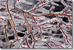
Weather Topic: What is Freezing Rain?
Home - Education - Precipitation - Freezing Rain
 Next Topic: Graupel
Freezing rain is a condition where precipitation which has fallen in the form of
water droplets reaches temperatures which are below freezing and freezes upon
coming into contact
with surface objects. The result of this precipitation is a glaze of ice which
can be damaging to plants and man-made structures. A severe onset of freezing
rain which results in a very thick glaze of ice is known as an ice storm.
Next Topic: Graupel
Weather Topic: What is Hail?
Home - Education - Precipitation - Hail
 Next Topic: Hole Punch Clouds
Hail is a form of precipitation which is recognized by large solid balls or
clumps of ice. Hail is created by thunderstorm clouds with strong updrafts of wind.
As the hailstones remain in the updraft, ice is deposited onto them until their
weight becomes heavy enough for them to fall to the earth's surface.
Hail storms can cause significant damage to crops, aircrafts, and man-made structures,
despite the fact that the duration is usually less than ten minutes.
Next Topic: Hole Punch Clouds
Current conditions powered by WeatherAPI.com


