Weather Alert in California
Coastal Flood Advisory issued February 17 at 9:19PM PST until February 18 at 12:00PM PST by NWS Los Angeles/Oxnard CA
AREAS AFFECTED: Ventura County Beaches
DESCRIPTION: * WHAT...For the Coastal Flood Advisory, minor coastal flooding. For the High Surf Advisory, large breaking waves of 8 to 10 feet with local sets to 12 feet, with dangerous rip currents. * WHERE...Ventura County Beaches. * WHEN...For the Coastal Flood Advisory, until noon PST Wednesday. For the High Surf Advisory, until 10 PM PST Friday. * IMPACTS...Flooding of sea water is likely, around the time of high tide, over vulnerable low-lying coastal areas such as parking lots, beaches, and walkways. Significant damage to roads or structures is NOT expected. There is an increased risk of ocean drowning. Rip currents can pull swimmers and surfers out to sea. Large breaking waves can cause injury, wash people off beaches and rocks, and capsize small boats near shore. * ADDITIONAL DETAILS...Minor coastal flooding around mid- morning time of high tide on Wednesday morning between 8 AM and 12 PM.
INSTRUCTION: Take the necessary actions to protect flood-prone property. Do NOT drive around barricades or through water of unknown depth. Remain out of the water due to dangerous surf conditions, or stay near occupied lifeguard towers. Rock jetties can be deadly in such conditions, stay off the rocks.
Want more detail? Get the Complete 7 Day and Night Detailed Forecast!
Current U.S. National Radar--Current
The Current National Weather Radar is shown below with a UTC Time (subtract 5 hours from UTC to get Eastern Time).

National Weather Forecast--Current
The Current National Weather Forecast and National Weather Map are shown below.

National Weather Forecast for Tomorrow
Tomorrow National Weather Forecast and Tomorrow National Weather Map are show below.

North America Water Vapor (Moisture)
This map shows recent moisture content over North America. Bright and colored areas show high moisture (ie, clouds); brown indicates very little moisture present; black indicates no moisture.

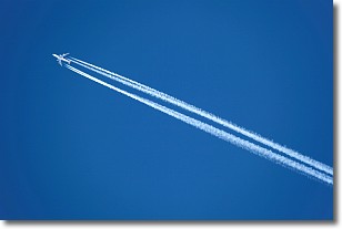
Weather Topic: What are Contrails?
Home - Education - Cloud Types - Contrails
 Next Topic: Cumulonimbus Clouds
A contrail is an artificial cloud, created by the passing of an
aircraft.
Contrails form because water vapor in the exhaust of aircraft engines is suspended
in the air under certain temperatures and humidity conditions. These contrails
are called exhaust contrails.
Another type of contrail can form due to a temporary reduction in air pressure
moving over the plane's surface, causing condensation.
These are called aerodynamic contrails.
When you can see your breath on a cold day, it is also because of condensation.
The reason contrails last longer than the condensation from your breath is
because the water in contrails freezes into ice particles.
Next Topic: Cumulonimbus Clouds
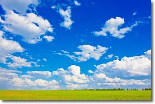
Weather Topic: What are Cumulus Clouds?
Home - Education - Cloud Types - Cumulus Clouds
 Next Topic: Drizzle
Cumulus clouds are fluffy and textured with rounded tops, and
may have flat bottoms. The border of a cumulus cloud
is clearly defined, and can have the appearance of cotton or cauliflower.
Cumulus clouds form at low altitudes (rarely above 2 km) but can grow very tall,
becoming cumulus congestus and possibly the even taller cumulonimbus clouds.
When cumulus clouds become taller, they have a greater chance of producing precipitation.
Next Topic: Drizzle
Current conditions powered by WeatherAPI.com


