Weather Alert in Texas
Flood Warning issued September 1 at 5:32PM CDT until September 2 at 11:23AM CDT by NWS Midland/Odessa TX
AREAS AFFECTED: Presidio, TX
DESCRIPTION: ...The National Weather Service in Midland/Odessa TX has issued a Flood Warning for the following rivers in Texas... Rio Grande at Rio Grande at Presidio Vehicle Bridge affecting Presidio County. Rio Grande below Rio Grande below Rio Conchos near Presidio, Texas affecting Presidio County. For the Rio Grande...including Rio Grande above Rio Conchos near Presidio, Texas, Rio Grande at Presidio Vehicle Bridge, Rio Grande below Rio Conchos near Presidio, Texas, Rio Grande near Castolon, Texas, Rio Grande at Johnson Ranch near Castolon, Texas, Rio Grande at Rio Grande Village, BBNP, Texas, Rio Grande near Dryden, Texas, Terlingua Creek near Terlingua, Texas...Minor flooding is forecast. * WHAT...Minor flooding is forecast. * WHERE...Rio Grande below Rio Grande below Rio Conchos near Presidio, Texas. * WHEN...Until late tomorrow morning. * IMPACTS...At 9.0 feet (2.7 meters), the river reaches minor flood stage, and low lying areas begin to flood. At 11.0 feet (3.4 meters), minor flooding continues along the river. Irrigation pumps may need to be removed. No threats to residences or other structures are known to occur. * ADDITIONAL DETAILS... - At 5:15 PM CDT Monday the stage was 8.8 feet (2.7 meters). - Bankfull stage is 8.0 feet (2.4 meters). - Forecast...The river will rise above flood stage this evening to 10.1 feet (3.1 meters) late this evening. It will then fall below flood stage late this evening to 2.9 feet (0.9 meters) Wednesday morning. It will rise to 3.0 feet (0.9 meters) late Wednesday morning. It will then fall again and remain below flood stage. - Flood stage is 9.0 feet (2.7 meters). - http://www.weather.gov/safety/flood
INSTRUCTION: Turn around, don't drown when encountering flooded roads. Most flood deaths occur in vehicles. Motorists should not attempt to drive around barricades or drive cars through flooded areas. Caution is urged when walking near riverbanks. Additional information is available at www.weather.gov. Tuesday morning at 715 AM CDT.
Want more detail? Get the Complete 7 Day and Night Detailed Forecast!
Current U.S. National Radar--Current
The Current National Weather Radar is shown below with a UTC Time (subtract 5 hours from UTC to get Eastern Time).

National Weather Forecast--Current
The Current National Weather Forecast and National Weather Map are shown below.

National Weather Forecast for Tomorrow
Tomorrow National Weather Forecast and Tomorrow National Weather Map are show below.

North America Water Vapor (Moisture)
This map shows recent moisture content over North America. Bright and colored areas show high moisture (ie, clouds); brown indicates very little moisture present; black indicates no moisture.

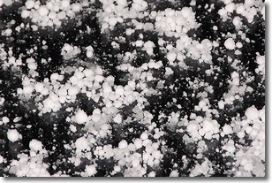
Weather Topic: What is Graupel?
Home - Education - Precipitation - Graupel
 Next Topic: Hail
Graupel is a form of precipitation that is created by atmospheric conditions
which cause supercooled water droplets to contact snow crystals and freeze to
their surface.
Sometimes known as soft hail or snow pellets, graupel is delicate and easily
destroyed by touch. Whereas hail usually falls during severe weather, graupel
doesn't require such conditions to form, and can form in mild precipitation
similar to situations which produce snowfall.
Next Topic: Hail
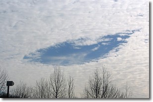
Weather Topic: What are Hole Punch Clouds?
Home - Education - Cloud Types - Hole Punch Clouds
 Next Topic: Mammatus Clouds
A hole punch cloud is an unusual occurrence when a disk-shaped
hole appears in a cirrostratus, cirrocumulus, or altocumulus cloud.
When part of the cloud forms ice crystals, water droplets in the surrounding area
of the cloud evaporate. The effect of this process produces a large elliptical
gap in the cloud. The hole punch cloud formation is rare, but it is not specific
to any geographic area.
Other names which have been used to describe this phenomena include fallstreak hole,
skypunch, and cloud hole.
Next Topic: Mammatus Clouds
Current conditions powered by WeatherAPI.com


