Weather Alert in Alaska
Winter Weather Advisory issued February 24 at 12:42PM AKST until February 26 at 4:00PM AKST by NWS Juneau AK
AREAS AFFECTED: City and Borough of Sitka; Prince of Wales Island
DESCRIPTION: ...PERIODS OF SNOW THROUGH MID WEEK... .Light snow continuing in various inland areas this afternoon with around 2 to 4 inches already accumulated in Juneau and Petersburg. There should be a brief break in the snow tonight before more snow showers move in from the West Wednesday into Wednesday night. Snow accumulations will be highly variable Wednesday into Wednesday night with W to SW orientied slopes favored for higher snow totals. * WHAT...Snow expected. Total snow accumulations of 4 to 7 inches. * WHERE...City and Borough of Sitka and Prince of Wales Island. * WHEN...From 6 PM Wednesday to 4 PM AKST Thursday. * IMPACTS...Travel could be difficult. The hazardous conditions could impact the morning or evening commute. * ADDITIONAL DETAILS...Snow accumulations will be highly variable with localized locations having a chance of seeing accumulations a few inches higher or lower then the above range.
INSTRUCTION: Slow down and use caution while traveling. People are urged to prepare their property before the onset of winter weather. For the latest road conditions, where available, call 5 1 1 or visit 511.alaska.gov.
Want more detail? Get the Complete 7 Day and Night Detailed Forecast!
Current U.S. National Radar--Current
The Current National Weather Radar is shown below with a UTC Time (subtract 5 hours from UTC to get Eastern Time).

National Weather Forecast--Current
The Current National Weather Forecast and National Weather Map are shown below.

National Weather Forecast for Tomorrow
Tomorrow National Weather Forecast and Tomorrow National Weather Map are show below.

North America Water Vapor (Moisture)
This map shows recent moisture content over North America. Bright and colored areas show high moisture (ie, clouds); brown indicates very little moisture present; black indicates no moisture.

Weather Topic: What are Nimbostratus Clouds?
Home - Education - Cloud Types - Nimbostratus Clouds
 Next Topic: Precipitation
A nimbostratus cloud is similar to a stratus cloud in its formless,
smooth appearance. However, a nimbostratus cloud is darker than a stratus cloud,
because it is thicker.
Unlike a stratus cloud, a nimbostratus cloud typically brings with it the threat
of moderate to heavy precipitation. In some cases, the precipitation may evaporate
before reaching the ground, a phenomenon known as virga.
Next Topic: Precipitation
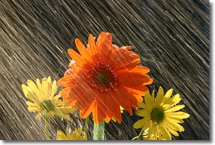
Weather Topic: What is Rain?
Home - Education - Precipitation - Rain
 Next Topic: Shelf Clouds
Precipitation in the form of water droplets is called rain.
Rain generally has a tendency to fall with less intensity over a greater period
of time, and when rainfall is more severe it is usually less sustained.
Rain is the most common form of precipitation and happens with greater frequency
depending on the season and regional influences. Cities have been shown to have
an observable effect on rainfall, due to an effect called the urban heat island.
Compared to upwind, monthly rainfall between twenty and forty miles downwind of
cities is 30% greater.
Next Topic: Shelf Clouds
Current conditions powered by WeatherAPI.com


