Weather Alert in California
Flash Flood Warning issued February 16 at 11:28AM PST until February 16 at 2:00PM PST by NWS Los Angeles/Oxnard CA
AREAS AFFECTED: Los Angeles, CA
DESCRIPTION: FFWLOX The National Weather Service in Los Angeles/Oxnard has issued a * Flash Flood Warning for... Much of Central and Southern Los Angeles County in southwestern California... Including Multiple Burn Scars. * Until 200 PM PST. * At 1128 AM PST, local law enforcement reported flash flooding already developing from heavy showers and thunderstorms across the warned area. The expected and observed rainfall rate is 0.5 to 0.75 inches in 15 minutes. Flash flooding is already occurring. Rock slides and mud slides are expected. Debris flows on the burn scars. HAZARD...Life threatening flash flooding. Thunderstorms producing flash flooding. Significant rock slides and mud slides. Debris flows. SOURCE...Law enforcement reported. IMPACT...Life threatening flash flooding of creeks and streams, urban areas, highways, streets and underpasses. Significant rock slides and mud slides. Debris flows. * Some locations that will experience flash flooding include... Alhambra, Downtown Los Angeles, Pasadena, Griffith Park, Hollywood, Burbank, Universal City, Mount Wilson, Inglewood, Beverly Hills, Whittier, Culver City, North Hollywood, Altadena, Eagle Rock, Glendale, La Canada Flintridge, Hancock Park, Hollywood Hills and Toluca Lake. Burn scars, such as Eaton and eastern Palisades.
INSTRUCTION: Turn around, don't drown when encountering flooded roads. Most flood deaths occur in vehicles. Be aware of your surroundings and do not drive on flooded roads, and be aware of rock slides and mud slides around high terrain. Follow direction of Emergency Management and Law Enforcement officials.
Want more detail? Get the Complete 7 Day and Night Detailed Forecast!
Current U.S. National Radar--Current
The Current National Weather Radar is shown below with a UTC Time (subtract 5 hours from UTC to get Eastern Time).

National Weather Forecast--Current
The Current National Weather Forecast and National Weather Map are shown below.

National Weather Forecast for Tomorrow
Tomorrow National Weather Forecast and Tomorrow National Weather Map are show below.

North America Water Vapor (Moisture)
This map shows recent moisture content over North America. Bright and colored areas show high moisture (ie, clouds); brown indicates very little moisture present; black indicates no moisture.

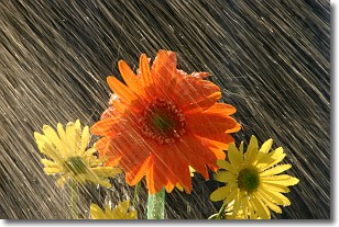
Weather Topic: What is Precipitation?
Home - Education - Precipitation - Precipitation
 Next Topic: Rain
Precipitation can refer to many different forms of water that
may fall from clouds. Precipitation occurs after a cloud has become saturated to
the point where its water particles are more dense than the air below the cloud.
In most cases, precipitation will reach the ground, but it is not uncommon for
precipitation to evaporate before it reaches the earth's surface.
When precipitation evaporates before it contacts the ground it is called Virga.
Graupel, hail, sleet, rain, drizzle, and snow are forms of precipitation, but fog
and mist are not considered precipitation because the water vapor which
constitutes them isn't dense enough to fall to the ground.
Next Topic: Rain
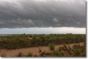
Weather Topic: What are Shelf Clouds?
Home - Education - Cloud Types - Shelf Clouds
 Next Topic: Sleet
A shelf cloud is similar to a wall cloud, but forms at the front
of a storm cloud, instead of at the rear, where wall clouds form.
A shelf cloud is caused by a series of events set into motion by the advancing
storm; first, cool air settles along the ground where precipitation has just fallen.
As the cool air is brought in, the warmer air is displaced, and rises above it,
because it is less dense. When the warmer air reaches the bottom of the storm cloud,
it begins to cool again, and the resulting condensation is a visible shelf cloud.
Next Topic: Sleet
Current conditions powered by WeatherAPI.com


