Weather Alert in California
Flash Flood Warning issued February 16 at 11:28AM PST until February 16 at 2:00PM PST by NWS Los Angeles/Oxnard CA
AREAS AFFECTED: Los Angeles, CA
DESCRIPTION: FFWLOX The National Weather Service in Los Angeles/Oxnard has issued a * Flash Flood Warning for... Much of Central and Southern Los Angeles County in southwestern California... Including Multiple Burn Scars. * Until 200 PM PST. * At 1128 AM PST, local law enforcement reported flash flooding already developing from heavy showers and thunderstorms across the warned area. The expected and observed rainfall rate is 0.5 to 0.75 inches in 15 minutes. Flash flooding is already occurring. Rock slides and mud slides are expected. Debris flows on the burn scars. HAZARD...Life threatening flash flooding. Thunderstorms producing flash flooding. Significant rock slides and mud slides. Debris flows. SOURCE...Law enforcement reported. IMPACT...Life threatening flash flooding of creeks and streams, urban areas, highways, streets and underpasses. Significant rock slides and mud slides. Debris flows. * Some locations that will experience flash flooding include... Alhambra, Downtown Los Angeles, Pasadena, Griffith Park, Hollywood, Burbank, Universal City, Mount Wilson, Inglewood, Beverly Hills, Whittier, Culver City, North Hollywood, Altadena, Eagle Rock, Glendale, La Canada Flintridge, Hancock Park, Hollywood Hills and Toluca Lake. Burn scars, such as Eaton and eastern Palisades.
INSTRUCTION: Turn around, don't drown when encountering flooded roads. Most flood deaths occur in vehicles. Be aware of your surroundings and do not drive on flooded roads, and be aware of rock slides and mud slides around high terrain. Follow direction of Emergency Management and Law Enforcement officials.
Want more detail? Get the Complete 7 Day and Night Detailed Forecast!
Current U.S. National Radar--Current
The Current National Weather Radar is shown below with a UTC Time (subtract 5 hours from UTC to get Eastern Time).

National Weather Forecast--Current
The Current National Weather Forecast and National Weather Map are shown below.

National Weather Forecast for Tomorrow
Tomorrow National Weather Forecast and Tomorrow National Weather Map are show below.

North America Water Vapor (Moisture)
This map shows recent moisture content over North America. Bright and colored areas show high moisture (ie, clouds); brown indicates very little moisture present; black indicates no moisture.

Weather Topic: What is Sleet?
Home - Education - Precipitation - Sleet
 Next Topic: Snow
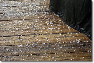
Sleet is a form of precipitation in which small ice pellets are the primary
components. These ice pellets are smaller and more translucent than hailstones,
and harder than graupel. Sleet is caused by specific atmospheric conditions and
therefore typically doesn't last for extended periods of time.
The condition which leads to sleet formation requires a warmer body of air to be
wedged in between two sub-freezing bodies of air. When snow falls through a warmer
layer of air it melts, and as it falls through the next sub-freezing body of air
it freezes again, forming ice pellets known as sleet. In some cases, water
droplets don't have time to freeze before reaching the surface and the result is
freezing rain.
Next Topic: Snow
Weather Topic: What are Stratocumulus Clouds?
Home - Education - Cloud Types - Stratocumulus Clouds
 Next Topic: Stratus Clouds
Stratocumulus clouds are similar to altocumulus clouds in their
fluffy appearance, but have a slightly darker shade due to their additional mass.
A good way to distinguish the two cloud types is to hold your hand out and measure
the size of an individual cloud; if it is the size of your thumb it is generally
an altocumulus cloud, if it is the size of your hand it is generally a
stratocumulus cloud.
It is uncommon for stratocumulus clouds to produce precipitation, but if they do
it is usually a light rain or snow.
Next Topic: Stratus Clouds
Current conditions powered by WeatherAPI.com


