Weather Alert in Idaho
Avalanche Watch issued February 16 at 6:24AM MST by NWS Pocatello ID
AREAS AFFECTED: Bear River Range
DESCRIPTION: AVAPIH * WHAT...Avalanche watch. Heavy snowfall and strong winds are expected to rapidly increase avalanche danger across northern Utah and southeast Idaho beginning Tuesday and continuing throughout the week. Expect dangerous and complex avalanche conditions to develop on many slopes, with large and natural and human- triggered avalanches likely. * WHERE...The Bear River Range and Wasatch Mountains. * WHEN...6 AM MST Monday through 6 AM MST Tuesday * IMPACTS...Dangerous avalanche conditions are expected to develop on many slopes. Avalanches can be triggered on slopes steeper than 30 degrees. They may also be triggered remotely from a distance or from below.
INSTRUCTION: Avoid traveling on or underneath steep terrain at mid and upper elevations in the backcountry. Carry and know how to use avalanche rescue equipment, including a transceiver, shovel and probe. Find safer riding conditions on slopes less than 30 degrees with no overhead hazard. Consult www.utahavalanchecenter.org or www.avalanche.org for more detailed information. Similar avalanche danger may exist at locations outside the coverage area of this or any avalanche center.
Want more detail? Get the Complete 7 Day and Night Detailed Forecast!
Current U.S. National Radar--Current
The Current National Weather Radar is shown below with a UTC Time (subtract 5 hours from UTC to get Eastern Time).

National Weather Forecast--Current
The Current National Weather Forecast and National Weather Map are shown below.

National Weather Forecast for Tomorrow
Tomorrow National Weather Forecast and Tomorrow National Weather Map are show below.

North America Water Vapor (Moisture)
This map shows recent moisture content over North America. Bright and colored areas show high moisture (ie, clouds); brown indicates very little moisture present; black indicates no moisture.

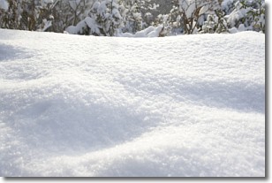
Weather Topic: What is Snow?
Home - Education - Precipitation - Snow
 Next Topic: Stratocumulus Clouds
Snow is precipitation taking the form of ice crystals. Each ice crystal, or snowflake,
has unique characteristics, but all of them grow in a hexagonal structure.
Snowfall can last for sustained periods of time and result in significant buildup
of snow on the ground.
On the earth's surface, snow starts out light and powdery, but as it begins to melt
it tends to become more granular, producing small bits of ice which have the consistency of
sand. After several cycles of melting and freezing, snow can become very dense
and ice-like, commonly known as snow pack.
Next Topic: Stratocumulus Clouds
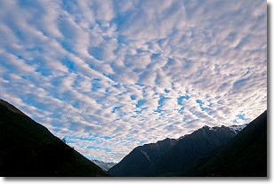
Weather Topic: What are Stratus Clouds?
Home - Education - Cloud Types - Stratus Clouds
 Next Topic: Wall Clouds
Stratus clouds are similar to altostratus clouds, but form at a
lower altitude and are identified by their fog-like appearance, lacking the
distinguishing features of most clouds.
Stratus clouds are wider than most clouds, and their base has a smooth, uniform
look which is lighter in color than a nimbostratus cloud.
The presence of a stratus cloud indicates the possibility of minor precipitation,
such as drizzle, but heavier precipitation does not typically arrive in the form
of a stratus cloud.
Next Topic: Wall Clouds
Current conditions powered by WeatherAPI.com


