Weather Alert in Iowa
Flood Warning issued July 16 at 10:44AM CDT until July 17 at 4:30PM CDT by NWS Quad Cities IA IL
AREAS AFFECTED: Benton, IA; Iowa, IA
DESCRIPTION: ...The Flood Warning is extended for the following rivers in Iowa... Iowa River at Marengo affecting Iowa and Benton Counties. ...The Flood Warning is cancelled for the following rivers in Illinois...Iowa... Mississippi River at Burlington affecting Des Moines, Henderson, Hancock and Lee Counties. Mississippi River at Gladstone LD18 affecting Des Moines and Henderson Counties. * WHAT...Minor flooding is occurring. * WHERE...Iowa River at Marengo. * WHEN...Until tomorrow afternoon. * IMPACTS...At 16.0 feet, Flood Stage. Water affects agricultural land along the river. Water is several feet deep in places. * ADDITIONAL DETAILS... - At 10:00 AM CDT Wednesday the stage was 15.5 feet. - Recent Activity...The river is near crest now. - Forecast...The river is expected to fall below flood stage tomorrow morning and continue falling to 10.6 feet Wednesday, July 23. - Flood stage is 15.0 feet.
INSTRUCTION: Turn around, don't drown when encountering flooded roads. Most flood deaths occur in vehicles. Motorists should not attempt to drive around barricades or drive cars through flooded areas. The next statement will be issued by this morning at 1145 AM CDT.
Want more detail? Get the Complete 7 Day and Night Detailed Forecast!
Current U.S. National Radar--Current
The Current National Weather Radar is shown below with a UTC Time (subtract 5 hours from UTC to get Eastern Time).

National Weather Forecast--Current
The Current National Weather Forecast and National Weather Map are shown below.

National Weather Forecast for Tomorrow
Tomorrow National Weather Forecast and Tomorrow National Weather Map are show below.

North America Water Vapor (Moisture)
This map shows recent moisture content over North America. Bright and colored areas show high moisture (ie, clouds); brown indicates very little moisture present; black indicates no moisture.

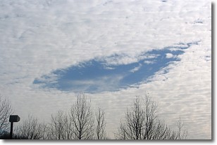
Weather Topic: What are Hole Punch Clouds?
Home - Education - Cloud Types - Hole Punch Clouds
 Next Topic: Mammatus Clouds
A hole punch cloud is an unusual occurrence when a disk-shaped
hole appears in a cirrostratus, cirrocumulus, or altocumulus cloud.
When part of the cloud forms ice crystals, water droplets in the surrounding area
of the cloud evaporate. The effect of this process produces a large elliptical
gap in the cloud. The hole punch cloud formation is rare, but it is not specific
to any geographic area.
Other names which have been used to describe this phenomena include fallstreak hole,
skypunch, and cloud hole.
Next Topic: Mammatus Clouds
Weather Topic: What are Nimbostratus Clouds?
Home - Education - Cloud Types - Nimbostratus Clouds
 Next Topic: Precipitation
A nimbostratus cloud is similar to a stratus cloud in its formless,
smooth appearance. However, a nimbostratus cloud is darker than a stratus cloud,
because it is thicker.
Unlike a stratus cloud, a nimbostratus cloud typically brings with it the threat
of moderate to heavy precipitation. In some cases, the precipitation may evaporate
before reaching the ground, a phenomenon known as virga.
Next Topic: Precipitation
Current conditions powered by WeatherAPI.com


