Weather Alert in Arizona
Flash Flood Warning issued August 26 at 3:42PM MST until August 26 at 6:15PM MST by NWS Flagstaff AZ
AREAS AFFECTED: Yavapai, AZ
DESCRIPTION: At 341 PM MST, Doppler radar indicated thunderstorms producing heavy rain across the warned area. Between 0.5 and 1.5 inches of rain have fallen. Flash flooding is ongoing or expected to begin shortly. HAZARD...Life-threatening flash flooding. Thunderstorms producing flash flooding. SOURCE...Radar. IMPACT...Life-threatening flash flooding of low-water crossings, creeks, normally dry washes and roads. Some locations that will experience flash flooding include... Spring Valley, Cordes Junction, Cordes, Mayer, Arcosanti and Cordes Lakes. This includes the following creeks, washes and rivers... Cedar Creek, Yarber Wash, Brushy Wash, Indian Creek, Grapevine Creek, Hackberry Creek, Little Ash Creek, Sycamore Creek, Big Bug Creek, Ash Creek, Badger Spring Wash, Dry Creek, Turkey Creek, Antelope Creek, Agua Fria River and Mineral Creek.
INSTRUCTION: Turn around, don't drown when encountering flooded roads. Most flood deaths occur in vehicles. In hilly or mountainous terrain, there are many low water crossings which will become dangerous in heavy rain. Do not attempt to cross flooded roads. Find an alternate route.
Want more detail? Get the Complete 7 Day and Night Detailed Forecast!
Current U.S. National Radar--Current
The Current National Weather Radar is shown below with a UTC Time (subtract 5 hours from UTC to get Eastern Time).

National Weather Forecast--Current
The Current National Weather Forecast and National Weather Map are shown below.

National Weather Forecast for Tomorrow
Tomorrow National Weather Forecast and Tomorrow National Weather Map are show below.

North America Water Vapor (Moisture)
This map shows recent moisture content over North America. Bright and colored areas show high moisture (ie, clouds); brown indicates very little moisture present; black indicates no moisture.

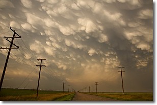
Weather Topic: What are Mammatus Clouds?
Home - Education - Cloud Types - Mammatus Clouds
 Next Topic: Nimbostratus Clouds
A mammatus cloud is a cloud with a unique feature which resembles
a web of pouches hanging along the base of the cloud.
In the United States, mammatus clouds tend to form in the warmer months, commonly
in the Midwest and eastern regions.
While they usually form at the bottom of a cumulonimbis cloud, they can also form
under altostratus, altocumulus, stratocumulus, and cirrus clouds. Mammatus clouds
warn that severe weather is close.
Next Topic: Nimbostratus Clouds
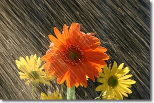
Weather Topic: What is Precipitation?
Home - Education - Precipitation - Precipitation
 Next Topic: Rain
Precipitation can refer to many different forms of water that
may fall from clouds. Precipitation occurs after a cloud has become saturated to
the point where its water particles are more dense than the air below the cloud.
In most cases, precipitation will reach the ground, but it is not uncommon for
precipitation to evaporate before it reaches the earth's surface.
When precipitation evaporates before it contacts the ground it is called Virga.
Graupel, hail, sleet, rain, drizzle, and snow are forms of precipitation, but fog
and mist are not considered precipitation because the water vapor which
constitutes them isn't dense enough to fall to the ground.
Next Topic: Rain
Current conditions powered by WeatherAPI.com


