Weather Alert in Wyoming
Special Weather Statement issued August 21 at 7:19PM MDT by NWS Rapid City SD
AREAS AFFECTED: Northern Campbell; Southern Campbell
DESCRIPTION: At 718 PM MDT, Doppler radar was tracking strong thunderstorms along a line extending from 9 miles northwest of Echeta to 11 miles northeast of Fort Reno Historical Site. Movement was east at 35 mph. HAZARD...Wind gusts of 50 to 55 mph and half inch hail. SOURCE...Radar indicated. IMPACT...Gusty winds could knock down tree limbs and blow around unsecured objects. Minor hail damage to vegetation is possible. Locations impacted include... Gillette, Coal Creek Mine, Rawhide Mine, Caballo Mine, Eagle Butte Mine, Cordero Rojo Mine, Dry Fork Mine, Belle Ayr Mine, Wyodak Mine, Buckskin Mine, Hilight Gas Plant, Echeta, Weston, Rozet, Savageton, Gillette Airport, and Camplex Event Facility. This includes Interstate 90 in Wyoming between Mile Markers 96 and 143.
INSTRUCTION: If outdoors, consider seeking shelter inside a building.
Want more detail? Get the Complete 7 Day and Night Detailed Forecast!
Current U.S. National Radar--Current
The Current National Weather Radar is shown below with a UTC Time (subtract 5 hours from UTC to get Eastern Time).

National Weather Forecast--Current
The Current National Weather Forecast and National Weather Map are shown below.

National Weather Forecast for Tomorrow
Tomorrow National Weather Forecast and Tomorrow National Weather Map are show below.

North America Water Vapor (Moisture)
This map shows recent moisture content over North America. Bright and colored areas show high moisture (ie, clouds); brown indicates very little moisture present; black indicates no moisture.

Weather Topic: What is Freezing Rain?
Home - Education - Precipitation - Freezing Rain
 Next Topic: Graupel
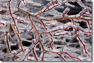
Freezing rain is a condition where precipitation which has fallen in the form of
water droplets reaches temperatures which are below freezing and freezes upon
coming into contact
with surface objects. The result of this precipitation is a glaze of ice which
can be damaging to plants and man-made structures. A severe onset of freezing
rain which results in a very thick glaze of ice is known as an ice storm.
Next Topic: Graupel
Weather Topic: What is Hail?
Home - Education - Precipitation - Hail
 Next Topic: Hole Punch Clouds
Hail is a form of precipitation which is recognized by large solid balls or
clumps of ice. Hail is created by thunderstorm clouds with strong updrafts of wind.
As the hailstones remain in the updraft, ice is deposited onto them until their
weight becomes heavy enough for them to fall to the earth's surface.
Hail storms can cause significant damage to crops, aircrafts, and man-made structures,
despite the fact that the duration is usually less than ten minutes.
Next Topic: Hole Punch Clouds
Current conditions powered by WeatherAPI.com


