Weather Alert in California
Fire Weather Watch issued July 28 at 12:59PM PDT until July 30 at 11:00PM PDT by NWS Medford OR
AREAS AFFECTED: Siskiyou County from the Cascade Mountains East and South to Mt Shasta
DESCRIPTION: ...FIRE WEATHER WATCH IN EFFECT FROM WEDNESDAY AFTERNOON THROUGH WEDNESDAY EVENING FOR ABUNDANT LIGHTNING ON DRY FUELS FOR FIRE WEATHER ZONE 284... * IMPACTS...Abundant lightning on dry fuels resulting in the potential for numerous new fire starts. * AFFECTED AREA...All of Fire Weather Zone 284. * THUNDERSTORMS...For Tuesday, storms are expected to be isolated with scattered activity focused farther east. On Wednesday, scattered to widespread thunderstorms with abundant lightning are possible. Storms are likely to be wet, but lightning strikes outside of precipitation cores are possible, and cause for concern for new fire starts. * OUTFLOW WINDS...Gusts of 35 to 50 mph could travel outward up to 25 miles from thunderstorm cores. * DETAILED URL...View the hazard area in detail at https://www.wrh.noaa.gov/map/?wfo=mfr
INSTRUCTION: Follow all fire restrictions. Avoid activities that could cause sparks. Visit weather.gov/medford/wildfire for links to fire restrictions in your area. If you have not packed your go kit yet, now is the time to do so. This includes items like important documents and essentials you cannot live without. Fill your vehicle's fuel tank. Visit ready.gov/kit for more information. A Fire Weather Watch means that critical fire weather conditions are possible during the valid watch time. These conditions could promote the rapid spread of wildfires which could become life- threatening. Check weather.gov/medford for forecast updates and a possible upgrade of the this watch to a Red Flag Warning.
Want more detail? Get the Complete 7 Day and Night Detailed Forecast!
Current U.S. National Radar--Current
The Current National Weather Radar is shown below with a UTC Time (subtract 5 hours from UTC to get Eastern Time).

National Weather Forecast--Current
The Current National Weather Forecast and National Weather Map are shown below.

National Weather Forecast for Tomorrow
Tomorrow National Weather Forecast and Tomorrow National Weather Map are show below.

North America Water Vapor (Moisture)
This map shows recent moisture content over North America. Bright and colored areas show high moisture (ie, clouds); brown indicates very little moisture present; black indicates no moisture.

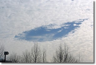
Weather Topic: What are Hole Punch Clouds?
Home - Education - Cloud Types - Hole Punch Clouds
 Next Topic: Mammatus Clouds
A hole punch cloud is an unusual occurrence when a disk-shaped
hole appears in a cirrostratus, cirrocumulus, or altocumulus cloud.
When part of the cloud forms ice crystals, water droplets in the surrounding area
of the cloud evaporate. The effect of this process produces a large elliptical
gap in the cloud. The hole punch cloud formation is rare, but it is not specific
to any geographic area.
Other names which have been used to describe this phenomena include fallstreak hole,
skypunch, and cloud hole.
Next Topic: Mammatus Clouds
Weather Topic: What are Nimbostratus Clouds?
Home - Education - Cloud Types - Nimbostratus Clouds
 Next Topic: Precipitation
A nimbostratus cloud is similar to a stratus cloud in its formless,
smooth appearance. However, a nimbostratus cloud is darker than a stratus cloud,
because it is thicker.
Unlike a stratus cloud, a nimbostratus cloud typically brings with it the threat
of moderate to heavy precipitation. In some cases, the precipitation may evaporate
before reaching the ground, a phenomenon known as virga.
Next Topic: Precipitation
Current conditions powered by WeatherAPI.com


