Weather Alert in Nebraska
Fire Weather Watch issued February 16 at 7:25AM CST until February 17 at 8:00PM CST by NWS North Platte NE
AREAS AFFECTED: Eastern Panhandle/Crescent Lake NWR; Sandhills/Valentine NWR/Nebraska National Forest; Niobrara Valley/Fort Niobrara NWR/Samuel R McKelvie National Forest; Loup Rivers Basin; Frenchman Basin; Loess Plains
DESCRIPTION: ...CRITICAL FIRE WEATHER CONDITIONS PROBABLE TUESDAY AFTERNOON THROUGH MID EVENING... .Intense low pressure will develop over southern South Dakota Tuesday morning. The strong west winds will combine with very dry air, leading to probable critical fire weather conditions across all of western and north central Nebraska Tuesday afternoon into the mid evening hours. * AFFECTED AREA...Fire Weather Zone 204 Eastern Panhandle/Crescent Lake NWR, Fire Weather Zone 206 Sandhills/Valentine NWR/Nebraska National Forest, Fire Weather Zone 208 Niobrara Valley/Fort Niobrara NWR/Samuel R McKelvie National Forest, Fire Weather Zone 209 Loup Rivers Basin, Fire Weather Zone 210 Frenchman Basin and Fire Weather Zone 219 Loess Plains. * TIMING...Noon to 8 PM CST (11 AM to 7 PM MST) Tuesday. * WINDS...West 25 to 35 mph with gusts up to 55 mph, strongest winds west of Highway 83. * RELATIVE HUMIDITY...As low as 10 to 15 percent. * TEMPERATURES...Mid 60s to mid 70s. * LIGHTNING...None expected. * IMPACTS...Any fire starts will have a high potential to spread rapidly and will be difficult to control.
INSTRUCTION: A Fire Weather Watch means that critical fire weather conditions are forecast to occur. Listen for later forecasts and possible Red Flag Warnings.
Want more detail? Get the Complete 7 Day and Night Detailed Forecast!
Current U.S. National Radar--Current
The Current National Weather Radar is shown below with a UTC Time (subtract 5 hours from UTC to get Eastern Time).

National Weather Forecast--Current
The Current National Weather Forecast and National Weather Map are shown below.

National Weather Forecast for Tomorrow
Tomorrow National Weather Forecast and Tomorrow National Weather Map are show below.

North America Water Vapor (Moisture)
This map shows recent moisture content over North America. Bright and colored areas show high moisture (ie, clouds); brown indicates very little moisture present; black indicates no moisture.

Weather Topic: What are Stratus Clouds?
Home - Education - Cloud Types - Stratus Clouds
 Next Topic: Wall Clouds
Stratus clouds are similar to altostratus clouds, but form at a
lower altitude and are identified by their fog-like appearance, lacking the
distinguishing features of most clouds.
Stratus clouds are wider than most clouds, and their base has a smooth, uniform
look which is lighter in color than a nimbostratus cloud.
The presence of a stratus cloud indicates the possibility of minor precipitation,
such as drizzle, but heavier precipitation does not typically arrive in the form
of a stratus cloud.
Next Topic: Wall Clouds
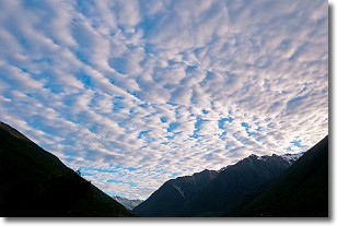
Weather Topic: What are Altocumulus Clouds?
Home - Education - Cloud Types - Altocumulus Clouds
 Next Topic: Altostratus Clouds
Similar to cirrocumulus clouds, altocumulus clouds are
characterized by cloud patches. They are distinguished by larger cloudlets
than cirrocumulus clouds but are still smaller than stratocumulus clouds.
Altocumulus clouds most commonly form in middle altitudes (between 2 and 5 km)
and may resemble, at times, the shape of a flying saucer.
These uncommon formations, called altocumulus lenticularis, are created by uplift
in the atmosphere and are most often seen in close proximity to mountains.
Next Topic: Altostratus Clouds
Current conditions powered by WeatherAPI.com


