Weather Alert in Texas
Wind Advisory issued February 24 at 12:22AM CST until February 24 at 6:00PM CST by NWS Fort Worth TX
AREAS AFFECTED: Grayson; Fannin; Lamar; Denton; Collin; Hunt; Delta; Hopkins; Parker; Tarrant; Dallas; Rockwall; Kaufman; Van Zandt; Rains; Hood; Somervell; Johnson; Ellis; Henderson; Hamilton; Bosque; Hill; Navarro; Coryell; Bell; McLennan
DESCRIPTION: * WHAT...South winds 20 to 25 mph with gusts up to 35 mph expected. * WHERE...Portions of north central and northeast Texas. * WHEN...From noon today to 6 PM CST this evening. * IMPACTS...Unsecured outdoor items may be blown around in the wind. Driving on area roadways may become difficult, especially for high-profile vehicles. Small tree limbs could break and cause damage.
INSTRUCTION: A Wind Advisory means that sustained winds of at least 20 to 30 mph are expected. Winds this strong can make driving difficult, especially for high profile vehicles. Boaters should use extra caution when venturing onto area lakes. Residents may wish to take action to secure trash cans, lawn furniture, and other lightweight outdoor objects that may be blown around in the strong winds.
Want more detail? Get the Complete 7 Day and Night Detailed Forecast!
Current U.S. National Radar--Current
The Current National Weather Radar is shown below with a UTC Time (subtract 5 hours from UTC to get Eastern Time).

National Weather Forecast--Current
The Current National Weather Forecast and National Weather Map are shown below.

National Weather Forecast for Tomorrow
Tomorrow National Weather Forecast and Tomorrow National Weather Map are show below.

North America Water Vapor (Moisture)
This map shows recent moisture content over North America. Bright and colored areas show high moisture (ie, clouds); brown indicates very little moisture present; black indicates no moisture.

Weather Topic: What is Freezing Rain?
Home - Education - Precipitation - Freezing Rain
 Next Topic: Graupel
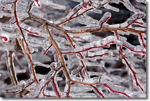
Freezing rain is a condition where precipitation which has fallen in the form of
water droplets reaches temperatures which are below freezing and freezes upon
coming into contact
with surface objects. The result of this precipitation is a glaze of ice which
can be damaging to plants and man-made structures. A severe onset of freezing
rain which results in a very thick glaze of ice is known as an ice storm.
Next Topic: Graupel
Weather Topic: What is Hail?
Home - Education - Precipitation - Hail
 Next Topic: Hole Punch Clouds
Hail is a form of precipitation which is recognized by large solid balls or
clumps of ice. Hail is created by thunderstorm clouds with strong updrafts of wind.
As the hailstones remain in the updraft, ice is deposited onto them until their
weight becomes heavy enough for them to fall to the earth's surface.
Hail storms can cause significant damage to crops, aircrafts, and man-made structures,
despite the fact that the duration is usually less than ten minutes.
Next Topic: Hole Punch Clouds
Current conditions powered by WeatherAPI.com


