Weather Alert in Oregon
Extreme Heat Watch issued August 21 at 12:08PM PDT until August 27 at 9:00PM PDT by NWS Pendleton OR
AREAS AFFECTED: Eastern Columbia River Gorge of Oregon; Lower Columbia Basin of Oregon; Foothills of the Northern Blue Mountains of Oregon; Foothills of the Southern Blue Mountains of Oregon; North Central Oregon; Eastern Columbia River Gorge of Washington; Kittitas Valley; Yakima Valley; Lower Columbia Basin of Washington; Foothills of the Blue Mountains of Washington; Simcoe Highlands; Lower Slopes of the Eastern Washington Cascades Crest
DESCRIPTION: * WHAT...Dangerously hot conditions with high temperatures of 95 to 105 degrees possible. This will pose a major to extreme risk of heat-related illness. * WHERE...Portions of north central and northeast Oregon and central, south central, and southeast Washington. * WHEN...From Saturday afternoon through Wednesday evening. * IMPACTS...Heat related illnesses increase significantly during extreme heat events. Extreme heat will significantly increase the risk of heat-related illnesses for much of the population, especially those who are heat sensitive and those without effective cooling or adequate hydration.
INSTRUCTION: Drink plenty of fluids, stay in an air-conditioned room, stay out of the sun, and check up on relatives and neighbors. Young children and pets should never be left unattended in vehicles under any circumstances. Monitor the latest forecasts and warnings for updates.
Want more detail? Get the Complete 7 Day and Night Detailed Forecast!
Current U.S. National Radar--Current
The Current National Weather Radar is shown below with a UTC Time (subtract 5 hours from UTC to get Eastern Time).

National Weather Forecast--Current
The Current National Weather Forecast and National Weather Map are shown below.

National Weather Forecast for Tomorrow
Tomorrow National Weather Forecast and Tomorrow National Weather Map are show below.

North America Water Vapor (Moisture)
This map shows recent moisture content over North America. Bright and colored areas show high moisture (ie, clouds); brown indicates very little moisture present; black indicates no moisture.

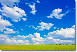
Weather Topic: What are Cumulus Clouds?
Home - Education - Cloud Types - Cumulus Clouds
 Next Topic: Drizzle
Cumulus clouds are fluffy and textured with rounded tops, and
may have flat bottoms. The border of a cumulus cloud
is clearly defined, and can have the appearance of cotton or cauliflower.
Cumulus clouds form at low altitudes (rarely above 2 km) but can grow very tall,
becoming cumulus congestus and possibly the even taller cumulonimbus clouds.
When cumulus clouds become taller, they have a greater chance of producing precipitation.
Next Topic: Drizzle
Weather Topic: What is Evaporation?
Home - Education - Precipitation - Evaporation
 Next Topic: Fog
Evaporation is the process which returns water from the earth
back to the atmosphere, and is another crucial process in the water cycle.
Evaporation is the transformation of liquid into gas, and it happens because
molecules are excited by the application of energy and turn into vapor.
In order for water to evaporate it has to be on the surface of a body of water.
Next Topic: Fog
Current conditions powered by WeatherAPI.com


