Weather Alert in Texas
Dense Fog Advisory issued February 12 at 9:13PM CST until February 13 at 9:00AM CST by NWS Houston/Galveston TX
AREAS AFFECTED: Northern Liberty; Inland Harris; Chambers; Wharton; Fort Bend; Inland Jackson; Inland Matagorda; Inland Brazoria; Inland Galveston; Southern Liberty; Coastal Harris; Coastal Jackson; Coastal Matagorda; Coastal Brazoria; Coastal Galveston; Matagorda Islands; Brazoria Islands; Galveston Island; Bolivar Peninsula
DESCRIPTION: * WHAT...Visibility one quarter mile or less in dense fog. * WHERE...Portions of south central and southeast Texas. * WHEN...Until 9 AM CST Friday. * IMPACTS...Low visibility could make driving conditions hazardous. * ADDITIONAL DETAILS...Dense fog is expected to develop within the next hour or so and persist through mid-morning. The advisory will likely expand further inland through the night.
INSTRUCTION: If driving, slow down, use your headlights, and leave plenty of distance ahead of you.
Want more detail? Get the Complete 7 Day and Night Detailed Forecast!
Current U.S. National Radar--Current
The Current National Weather Radar is shown below with a UTC Time (subtract 5 hours from UTC to get Eastern Time).

National Weather Forecast--Current
The Current National Weather Forecast and National Weather Map are shown below.

National Weather Forecast for Tomorrow
Tomorrow National Weather Forecast and Tomorrow National Weather Map are show below.

North America Water Vapor (Moisture)
This map shows recent moisture content over North America. Bright and colored areas show high moisture (ie, clouds); brown indicates very little moisture present; black indicates no moisture.

Weather Topic: What are Altostratus Clouds?
Home - Education - Cloud Types - Altostratus Clouds
 Next Topic: Cirrocumulus Clouds
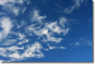
Altostratus clouds form at mid to high-level altitudes
(between 2 and 7 km) and are created by a warm, stable air mass which causes
water vapor
to condense as it rise through the atmosphere. Usually altostratus clouds are
featureless sheets characterized by a uniform color.
In some cases, wind punching through the cloud formation may give it a waved
appearance, called altostratus undulatus. Altostratus clouds
are commonly seen with other cloud formations accompanying them.
Next Topic: Cirrocumulus Clouds
Weather Topic: What are Cirrostratus Clouds?
Home - Education - Cloud Types - Cirrostratus Clouds
 Next Topic: Cirrus Clouds
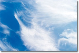
Cirrostratus clouds are high, thin clouds that form above
20,000 feet and are made mostly of ice crystals. They sometimes look like giant
feathers, horse tails, or curls of hair in the sky.
These clouds are pushed by the jet stream and can move at high speeds reaching
100 mph.
What do they indicate?
They indicate that a precipitation is likely within 24 hours.
Next Topic: Cirrus Clouds
Current conditions powered by WeatherAPI.com


