Weather Alert in Oregon
Extreme Heat Warning issued August 21 at 2:42PM PDT until August 26 at 5:00AM PDT by NWS Portland OR
AREAS AFFECTED: Lower Columbia River; Tualatin Valley; West Hills and Chehalem Mountains; Inner Portland Metro; East Portland Metro; Outer Southeast Portland Metro; West Central Willamette Valley; East Central Willamette Valley; Benton County Lowlands; Linn County Lowlands; Lane County Lowlands; West Columbia River Gorge of Oregon above 500 ft; West Columbia River Gorge I-84 Corridor; Upper Hood River Valley; Central Columbia River Gorge I-84 Corridor; Clackamas County Cascade Foothills; Cascade Foothills of Marion and Linn Counties; Lane County Cascade Foothills; Cowlitz County Lowlands; North Clark County Lowlands; Inner Vancouver Metro; East Clark County Lowlands; West Columbia River Gorge - SR 14; Central Columbia River Gorge - SR 14
DESCRIPTION: * WHAT...Dangerously hot conditions with high temperatures of 96-103F and overnight low temperatures of 60-70F expected, except low to mid 70s in the Columbia River Gorge. * WHERE...Greater Portland/Vancouver Metro, Western and Central Columbia River Gorge, the Corbett area and the Hood River Valley, Central and Southern Willamette Valley, Foothills of the Northern and Central Oregon Cascades, and Lower Columbia River and Cowlitz River Valleys. * WHEN...From 11 AM Friday to 5 AM PDT Tuesday. * IMPACTS...Heat related illnesses increase significantly during extreme heat events, especially for those spending time outdoors or without access to adequate cooling. * ADDITIONAL DETAILS...Friday and Saturday will be the hottest days. The warmest overnight lows are expected to occur in the Columbia River Gorge and in urban areas from Salem northward.
INSTRUCTION: Drink plenty of fluids, stay in a cool place during the heat of the day, stay out of the sunshine, and check up on relatives and neighbors. For those without air conditioning, use fans to keep air moving. Keeps windows closed during the day and open at night, unless air quality is degraded due to wildfire smoke. Do not leave young children and pets in unattended vehicles. Car interiors will reach lethal temperatures in a matter of minutes. Take extra precautions when outside. Wear lightweight and loose fitting clothing. Try to limit strenuous activities to early morning or evening. Take action when you see symptoms of heat exhaustion and heat stroke.
Want more detail? Get the Complete 7 Day and Night Detailed Forecast!
Current U.S. National Radar--Current
The Current National Weather Radar is shown below with a UTC Time (subtract 5 hours from UTC to get Eastern Time).

National Weather Forecast--Current
The Current National Weather Forecast and National Weather Map are shown below.

National Weather Forecast for Tomorrow
Tomorrow National Weather Forecast and Tomorrow National Weather Map are show below.

North America Water Vapor (Moisture)
This map shows recent moisture content over North America. Bright and colored areas show high moisture (ie, clouds); brown indicates very little moisture present; black indicates no moisture.

Weather Topic: What is Sleet?
Home - Education - Precipitation - Sleet
 Next Topic: Snow
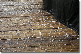
Sleet is a form of precipitation in which small ice pellets are the primary
components. These ice pellets are smaller and more translucent than hailstones,
and harder than graupel. Sleet is caused by specific atmospheric conditions and
therefore typically doesn't last for extended periods of time.
The condition which leads to sleet formation requires a warmer body of air to be
wedged in between two sub-freezing bodies of air. When snow falls through a warmer
layer of air it melts, and as it falls through the next sub-freezing body of air
it freezes again, forming ice pellets known as sleet. In some cases, water
droplets don't have time to freeze before reaching the surface and the result is
freezing rain.
Next Topic: Snow
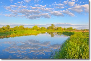
Weather Topic: What are Stratocumulus Clouds?
Home - Education - Cloud Types - Stratocumulus Clouds
 Next Topic: Stratus Clouds
Stratocumulus clouds are similar to altocumulus clouds in their
fluffy appearance, but have a slightly darker shade due to their additional mass.
A good way to distinguish the two cloud types is to hold your hand out and measure
the size of an individual cloud; if it is the size of your thumb it is generally
an altocumulus cloud, if it is the size of your hand it is generally a
stratocumulus cloud.
It is uncommon for stratocumulus clouds to produce precipitation, but if they do
it is usually a light rain or snow.
Next Topic: Stratus Clouds
Current conditions powered by WeatherAPI.com


