Weather Alert in Mississippi
Special Weather Statement issued September 6 at 5:10AM CDT by NWS Jackson MS
AREAS AFFECTED: Leflore; Grenada; Carroll; Montgomery; Holmes
DESCRIPTION: At 507 AM CDT, Doppler radar was tracking an outflow boundary producing gusty winds along a line extending from 7 miles northwest of Leflore to near Thornton. Movement was east at 40 mph. HAZARD...Wind gusts up to 40 mph. SOURCE...Radar indicated. IMPACT...Gusty winds could knock down tree limbs and blow around unsecured objects. Gusty winds will affect... Greenwood, Tchula, Holcomb, Avalon, Seven Pines, Tolarville, Teoc, Howard, and Leflore around 515 AM CDT. Malmaison and Bew Springs around 520 AM CDT. Grenada, Carrollton, Jefferson, North Carrollton, Black Hawk, Coila, and Brozville around 525 AM CDT. Lexington around 530 AM CDT.
INSTRUCTION: If outdoors, consider seeking shelter inside a building. High winds can bring down trees and large limbs resulting in serious injury or property damage. Exercise extreme caution when outdoors during such strong winds...and be especially aware of older trees. If on or near Grenada Lake, get out of the water and move indoors or inside a vehicle. Boats could be damaged or overturned in high winds and suddenly higher waves. Move to safe shelter now!
Want more detail? Get the Complete 7 Day and Night Detailed Forecast!
Current U.S. National Radar--Current
The Current National Weather Radar is shown below with a UTC Time (subtract 5 hours from UTC to get Eastern Time).

National Weather Forecast--Current
The Current National Weather Forecast and National Weather Map are shown below.

National Weather Forecast for Tomorrow
Tomorrow National Weather Forecast and Tomorrow National Weather Map are show below.

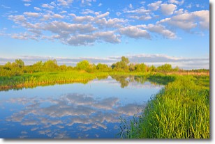
North America Water Vapor (Moisture)
This map shows recent moisture content over North America. Bright and colored areas show high moisture (ie, clouds); brown indicates very little moisture present; black indicates no moisture.

Weather Topic: What are Stratocumulus Clouds?
Home - Education - Cloud Types - Stratocumulus Clouds
 Next Topic: Stratus Clouds
Stratocumulus clouds are similar to altocumulus clouds in their
fluffy appearance, but have a slightly darker shade due to their additional mass.
A good way to distinguish the two cloud types is to hold your hand out and measure
the size of an individual cloud; if it is the size of your thumb it is generally
an altocumulus cloud, if it is the size of your hand it is generally a
stratocumulus cloud.
It is uncommon for stratocumulus clouds to produce precipitation, but if they do
it is usually a light rain or snow.
Next Topic: Stratus Clouds
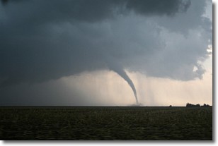
Weather Topic: What are Wall Clouds?
Home - Education - Cloud Types - Wall Clouds
 Next Topic: Altocumulus Clouds
A wall cloud forms underneath the base of a cumulonimbus cloud,
and can be a hotbed for deadly tornadoes.
Wall clouds are formed by air flowing into the cumulonimbus clouds, which can
result in the wall cloud descending from the base of the cumulonimbus cloud, or
rising fractus clouds which join to the base of the storm cloud as the wall cloud
takes shape.
Wall clouds can be very large, and in the Northern Hemisphere they generally
form at the southern edge of cumulonimbus clouds.
Next Topic: Altocumulus Clouds
Current conditions powered by WeatherAPI.com


