Weather Alert in Alaska
Winter Weather Advisory issued February 18 at 3:14PM AKST until February 20 at 6:00AM AKST by NWS Juneau AK
AREAS AFFECTED: Petersburg Borough; Western Kupreanof and Kuiu Island; City and Borough of Wrangell
DESCRIPTION: ...ACCUMULATING SNOW ACROSS THE PANHANDLE TO END THE WEEK... .A front moving across the gulf and developing low across the northern coast will bring snow showers to the panhandle beginning late Wednesday night. With stable cold dry continental air in place ahead of this system, precipitation is expected to remain snow throughout the event with high snow ratios. The initial frontal wave will push eastward into the panhandle with the northeast gulf coast seeing showers late tonight and highest snow accumulations expected along the outer coast with orographic enhancement. For most areas, snow is expected to be light and fluffy in nature due to cold temperatures both aloft and down to the surface. * WHAT...Snow expected. Total snow accumulations of 4 to 6 inches. * WHERE...Petersburg Borough, Western Kupreanof Island and Kuiu Island and City and Borough of Wrangell. * WHEN...From noon Thursday to 6 AM AKST Friday. * IMPACTS...Travel could be very difficult. * ADDITIONAL DETAILS...Snow showers will spread over the area Thursday afternoon and last into Friday morning. The heaviest snowfall rates are expected Thursday afternoon through Thursday evening. There remains uncertainty whether a heavier band of snow showers will develop and further impact these areas as the low drifts southward along the outer coast Friday morning.
INSTRUCTION: Slow down and use caution while traveling. People are urged to prepare their property before the onset of winter weather. For the latest road conditions, where available, call 5 1 1 or visit 511.alaska.gov.
Want more detail? Get the Complete 7 Day and Night Detailed Forecast!
Current U.S. National Radar--Current
The Current National Weather Radar is shown below with a UTC Time (subtract 5 hours from UTC to get Eastern Time).

National Weather Forecast--Current
The Current National Weather Forecast and National Weather Map are shown below.

National Weather Forecast for Tomorrow
Tomorrow National Weather Forecast and Tomorrow National Weather Map are show below.

North America Water Vapor (Moisture)
This map shows recent moisture content over North America. Bright and colored areas show high moisture (ie, clouds); brown indicates very little moisture present; black indicates no moisture.

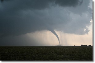
Weather Topic: What are Wall Clouds?
Home - Education - Cloud Types - Wall Clouds
 Next Topic: Altocumulus Clouds
A wall cloud forms underneath the base of a cumulonimbus cloud,
and can be a hotbed for deadly tornadoes.
Wall clouds are formed by air flowing into the cumulonimbus clouds, which can
result in the wall cloud descending from the base of the cumulonimbus cloud, or
rising fractus clouds which join to the base of the storm cloud as the wall cloud
takes shape.
Wall clouds can be very large, and in the Northern Hemisphere they generally
form at the southern edge of cumulonimbus clouds.
Next Topic: Altocumulus Clouds
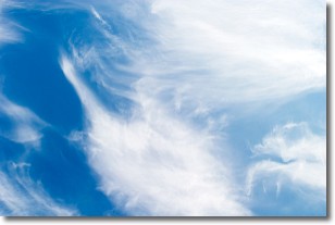
Weather Topic: What are Altostratus Clouds?
Home - Education - Cloud Types - Altostratus Clouds
 Next Topic: Cirrocumulus Clouds
Altostratus clouds form at mid to high-level altitudes
(between 2 and 7 km) and are created by a warm, stable air mass which causes
water vapor
to condense as it rise through the atmosphere. Usually altostratus clouds are
featureless sheets characterized by a uniform color.
In some cases, wind punching through the cloud formation may give it a waved
appearance, called altostratus undulatus. Altostratus clouds
are commonly seen with other cloud formations accompanying them.
Next Topic: Cirrocumulus Clouds
Current conditions powered by WeatherAPI.com


