Weather Alert in Ohio
Dense Fog Advisory issued February 16 at 3:19AM EST until February 16 at 11:00AM EST by NWS Pittsburgh PA
AREAS AFFECTED: Tuscarawas; Carroll; Columbiana; Coshocton; Harrison; Jefferson; Muskingum; Guernsey; Belmont; Noble; Monroe; Mercer; Venango; Forest; Lawrence; Butler; Clarion; Jefferson; Beaver; Allegheny; Armstrong; Washington; Greene; Westmoreland; Westmoreland Ridges; Fayette; Fayette Ridges; Indiana; Higher Elevations of Indiana; Hancock; Brooke; Ohio; Marshall; Wetzel; Marion; Monongalia; Ridges of Eastern Monongalia and Northwestern Preston; Preston; Eastern Preston; Western Tucker; Eastern Tucker
DESCRIPTION: * WHAT...Visibility one quarter mile or less in dense fog. Pockets of freezing fog are also expected early this morning, which could create slick spots on roads and sidewalks. * WHERE...Portions of east central Ohio, western Pennsylvania, and northern West Virginia. * WHEN...Until 11 AM EST this morning. * IMPACTS...Low visibility could make driving conditions hazardous. Pockets of freezing fog could also result in a glaze of ice on elevated surfaces and cause slick spots on roads and sidewalks, especially across portions of western Pennsylvania.
INSTRUCTION: If driving, slow down, use your headlights, and leave plenty of distance ahead of you. Slick spots due to ice on roads are also possible in areas of freezing fog.
Want more detail? Get the Complete 7 Day and Night Detailed Forecast!
Current U.S. National Radar--Current
The Current National Weather Radar is shown below with a UTC Time (subtract 5 hours from UTC to get Eastern Time).

National Weather Forecast--Current
The Current National Weather Forecast and National Weather Map are shown below.

National Weather Forecast for Tomorrow
Tomorrow National Weather Forecast and Tomorrow National Weather Map are show below.

North America Water Vapor (Moisture)
This map shows recent moisture content over North America. Bright and colored areas show high moisture (ie, clouds); brown indicates very little moisture present; black indicates no moisture.

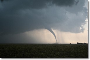
Weather Topic: What are Wall Clouds?
Home - Education - Cloud Types - Wall Clouds
 Next Topic: Altocumulus Clouds
A wall cloud forms underneath the base of a cumulonimbus cloud,
and can be a hotbed for deadly tornadoes.
Wall clouds are formed by air flowing into the cumulonimbus clouds, which can
result in the wall cloud descending from the base of the cumulonimbus cloud, or
rising fractus clouds which join to the base of the storm cloud as the wall cloud
takes shape.
Wall clouds can be very large, and in the Northern Hemisphere they generally
form at the southern edge of cumulonimbus clouds.
Next Topic: Altocumulus Clouds
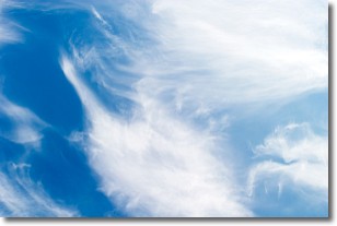
Weather Topic: What are Altostratus Clouds?
Home - Education - Cloud Types - Altostratus Clouds
 Next Topic: Cirrocumulus Clouds
Altostratus clouds form at mid to high-level altitudes
(between 2 and 7 km) and are created by a warm, stable air mass which causes
water vapor
to condense as it rise through the atmosphere. Usually altostratus clouds are
featureless sheets characterized by a uniform color.
In some cases, wind punching through the cloud formation may give it a waved
appearance, called altostratus undulatus. Altostratus clouds
are commonly seen with other cloud formations accompanying them.
Next Topic: Cirrocumulus Clouds
Current conditions powered by WeatherAPI.com


