Weather Alert in California
Winter Storm Warning issued February 16 at 11:46AM PST until February 18 at 4:00PM PST by NWS Eureka CA
AREAS AFFECTED: Northwestern Mendocino Interior; Northeastern Mendocino Interior; Northern Lake County; Southern Lake County
DESCRIPTION: * WHAT...Heavy snow above 2500 feet. Total snow accumulations 4 to 8 inches above 2500 feet expected, locally up to 14 inches for elevations above 3000 feet. Winds could gust as high as 45 mph. * WHERE...Lake County and Northern Mendocino Interior. * WHEN...From 10 PM Tuesday to 4 PM PST Wednesday. * IMPACTS...Roads, and especially bridges and overpasses, will likely become slick and hazardous. The strong winds and weight of snow on tree limbs may down power lines and could cause sporadic power outages. Plan on slippery road conditions. The hazardous conditions will impact the Tuesday morning and evening commutes.
INSTRUCTION: If you must travel, keep an extra flashlight, food, and water in your vehicle in case of an emergency. The latest road conditions for the state you are calling from can be obtained by calling 5 1 1. Persons are urged to stay indoors until conditions improve. If you must go outside, dress in layers. Several layers of clothes will keep you warmer than a single heavy coat. Cover exposed skin to reduce your risk of frostbite or hypothermia. Gloves, a scarf, and a hat will keep you from losing your body heat. Persons should consider delaying all travel. Motorists should use extreme caution if travel is absolutely necessary. Do not touch downed lines and report any power outages to your electric company. Travel is highly discouraged due to slick roadways and the possibility of downed trees and power lines.
Want more detail? Get the Complete 7 Day and Night Detailed Forecast!
Current U.S. National Radar--Current
The Current National Weather Radar is shown below with a UTC Time (subtract 5 hours from UTC to get Eastern Time).

National Weather Forecast--Current
The Current National Weather Forecast and National Weather Map are shown below.

National Weather Forecast for Tomorrow
Tomorrow National Weather Forecast and Tomorrow National Weather Map are show below.

North America Water Vapor (Moisture)
This map shows recent moisture content over North America. Bright and colored areas show high moisture (ie, clouds); brown indicates very little moisture present; black indicates no moisture.

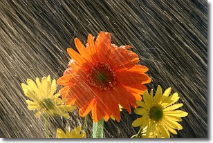
Weather Topic: What is Precipitation?
Home - Education - Precipitation - Precipitation
 Next Topic: Rain
Precipitation can refer to many different forms of water that
may fall from clouds. Precipitation occurs after a cloud has become saturated to
the point where its water particles are more dense than the air below the cloud.
In most cases, precipitation will reach the ground, but it is not uncommon for
precipitation to evaporate before it reaches the earth's surface.
When precipitation evaporates before it contacts the ground it is called Virga.
Graupel, hail, sleet, rain, drizzle, and snow are forms of precipitation, but fog
and mist are not considered precipitation because the water vapor which
constitutes them isn't dense enough to fall to the ground.
Next Topic: Rain
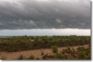
Weather Topic: What are Shelf Clouds?
Home - Education - Cloud Types - Shelf Clouds
 Next Topic: Sleet
A shelf cloud is similar to a wall cloud, but forms at the front
of a storm cloud, instead of at the rear, where wall clouds form.
A shelf cloud is caused by a series of events set into motion by the advancing
storm; first, cool air settles along the ground where precipitation has just fallen.
As the cool air is brought in, the warmer air is displaced, and rises above it,
because it is less dense. When the warmer air reaches the bottom of the storm cloud,
it begins to cool again, and the resulting condensation is a visible shelf cloud.
Next Topic: Sleet
Current conditions powered by WeatherAPI.com


