Weather Alert in North Carolina
Tropical Storm Warning issued August 21 at 10:48AM EDT by NWS Newport/Morehead City NC
AREAS AFFECTED: Mainland Dare
DESCRIPTION: * LOCATIONS AFFECTED - Manns Harbor - East Lake - Stumpy Point * WIND - LATEST LOCAL FORECAST: Below tropical storm force wind - Peak Wind Forecast: 20-30 mph with gusts to 40 mph - THREAT TO LIFE AND PROPERTY THAT INCLUDES TYPICAL FORECAST UNCERTAINTY IN TRACK, SIZE AND INTENSITY: Potential for wind 39 to 57 mph - The wind threat has remained nearly steady from the previous assessment. - PLAN: The sustained wind should remain less than tropical storm force. Conditions may still be gusty. - PREPARE: Listen for any instructions from local officials. - ACT: Ensure emergency readiness should the forecast change. - REALIZED IMPACTS: Being Assessed - Little to no additional wind impacts expected. Community officials are now assessing the extent of actual wind impacts accordingly. * STORM SURGE - No storm surge inundation forecast - THREAT TO LIFE AND PROPERTY THAT INCLUDES TYPICAL FORECAST UNCERTAINTY IN TRACK, SIZE AND INTENSITY: Little to no storm surge flooding - The storm surge threat has remained nearly steady from the previous assessment. - PLAN: There is little to no threat of storm surge flooding. Rough surf, coastal erosion, and life-threatening rip currents are possible. - PREPARE: Little to no preparations for storm surge flooding are needed. - ACT: Follow the instructions of local officials. Monitor forecasts. - POTENTIAL IMPACTS: Little to None - Little to no potential impacts from storm surge flooding. * FLOODING RAIN - LATEST LOCAL FORECAST: - Peak Rainfall Amounts: No additional significant rainfall forecast - THREAT TO LIFE AND PROPERTY THAT INCLUDES TYPICAL FORECAST UNCERTAINTY IN TRACK, SIZE AND INTENSITY: Little or no potential for flooding rain - The flooding rain threat has remained nearly steady from the previous assessment. - PLAN: There is little or no potential for flooding rain. - PREPARE: Little to no preparations are needed to protect against flooding rain at this time. - ACT: Monitor for changes to the forecast. - POTENTIAL IMPACTS: Little to None - Little to no potential impacts from flooding rain. * TORNADO - LATEST LOCAL FORECAST: - Situation is unfavorable for tornadoes - THREAT TO LIFE AND PROPERTY THAT INCLUDES TYPICAL FORECAST UNCERTAINTY IN TRACK, SIZE AND INTENSITY: Tornadoes not expected - The tornado threat has remained nearly steady from the previous assessment. - PLAN: Tornadoes are not expected. Showers and thunderstorms with gusty winds may still occur. - PREPARE: Little to no preparations needed to protect against tornadoes at this time. Keep informed of the latest tornado situation. - ACT: Listen for changes in the forecast. - POTENTIAL IMPACTS: Little to None - Little to no potential impacts from tornadoes. * FOR MORE INFORMATION: - http://ready.gov/hurricanes
INSTRUCTION: N/A
Want more detail? Get the Complete 7 Day and Night Detailed Forecast!
Current U.S. National Radar--Current
The Current National Weather Radar is shown below with a UTC Time (subtract 5 hours from UTC to get Eastern Time).

National Weather Forecast--Current
The Current National Weather Forecast and National Weather Map are shown below.

National Weather Forecast for Tomorrow
Tomorrow National Weather Forecast and Tomorrow National Weather Map are show below.

North America Water Vapor (Moisture)
This map shows recent moisture content over North America. Bright and colored areas show high moisture (ie, clouds); brown indicates very little moisture present; black indicates no moisture.

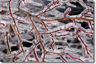
Weather Topic: What is Freezing Rain?
Home - Education - Precipitation - Freezing Rain
 Next Topic: Graupel
Freezing rain is a condition where precipitation which has fallen in the form of
water droplets reaches temperatures which are below freezing and freezes upon
coming into contact
with surface objects. The result of this precipitation is a glaze of ice which
can be damaging to plants and man-made structures. A severe onset of freezing
rain which results in a very thick glaze of ice is known as an ice storm.
Next Topic: Graupel
Weather Topic: What is Hail?
Home - Education - Precipitation - Hail
 Next Topic: Hole Punch Clouds
Hail is a form of precipitation which is recognized by large solid balls or
clumps of ice. Hail is created by thunderstorm clouds with strong updrafts of wind.
As the hailstones remain in the updraft, ice is deposited onto them until their
weight becomes heavy enough for them to fall to the earth's surface.
Hail storms can cause significant damage to crops, aircrafts, and man-made structures,
despite the fact that the duration is usually less than ten minutes.
Next Topic: Hole Punch Clouds
Current conditions powered by WeatherAPI.com


