Weather Alert in Iowa
Tornado Watch issued April 2 at 1:45PM CDT until April 2 at 8:00PM CDT by NWS Des Moines IA
AREAS AFFECTED: Appanoose, IA; Clarke, IA; Davis, IA; Decatur, IA; Jasper, IA; Lucas, IA; Mahaska, IA; Marion, IA; Marshall, IA; Monroe, IA; Polk, IA; Poweshiek, IA; Tama, IA; Wapello, IA; Warren, IA; Wayne, IA
DESCRIPTION: THE NATIONAL WEATHER SERVICE HAS ISSUED TORNADO WATCH 89 IN EFFECT UNTIL 8 PM CDT THIS EVENING FOR THE FOLLOWING AREAS IN IOWA THIS WATCH INCLUDES 16 COUNTIES IN CENTRAL IOWA JASPER MARSHALL POLK POWESHIEK TAMA IN SOUTH CENTRAL IOWA APPANOOSE CLARKE DECATUR LUCAS MAHASKA MARION MONROE WARREN WAYNE IN SOUTHEAST IOWA DAVIS WAPELLO THIS INCLUDES THE CITIES OF ALBIA, ALLERTON, BLOOMFIELD, CARLISLE, CENTERVILLE, CHARITON, CORYDON, DES MOINES, DYSART, GLADBROOK, GRINNELL, HUMESTON, INDIANOLA, KNOXVILLE, LAMONI, LEON, MARSHALLTOWN, NEWTON, NORWALK, OSCEOLA, OSKALOOSA, OTTUMWA, PELLA, SEYMOUR, TAMA, TOLEDO, AND TRAER. * PRIMARY THREATS INCLUDE... A FEW TORNADOES LIKELY WITH A COUPLE INTENSE TORNADOES POSSIBLE. SCATTERED DAMAGING WINDS AND ISOLATED SIGNIFICANT GUSTS TO 75 MPH LIKELY. SCATTERED LARGE HAIL AND ISOLATED VERY LARGE HAIL EVENTS TO 2 INCHES IN DIAMETER POSSIBLE. PROBABILITY TABLE: PROB OF 2 OR MORE TORNADOES : 70% PROB OF 1 OR MORE STRONG /EF2-EF5/ TORNADOES : 40% PROB OF 10 OR MORE SEVERE WIND EVENTS : 70% PROB OF 1 OR MORE WIND EVENTS >= 75 MPH : 60% PROB OF 10 OR MORE SEVERE HAIL EVENTS : 40% PROB OF 1 OR MORE HAIL EVENTS >= 2 INCHES : 30% PROB OF 6 OR MORE COMBINED SEVERE HAIL/WIND EVENTS : 90% MEAN STORM MOTION /MPH/ : E 40
INSTRUCTION: N/A
Want more detail? Get the Complete 7 Day and Night Detailed Forecast!
Current U.S. National Radar--Current
The Current National Weather Radar is shown below with a UTC Time (subtract 5 hours from UTC to get Eastern Time).

National Weather Forecast--Current
The Current National Weather Forecast and National Weather Map are shown below.

National Weather Forecast for Tomorrow
Tomorrow National Weather Forecast and Tomorrow National Weather Map are show below.

North America Water Vapor (Moisture)
This map shows recent moisture content over North America. Bright and colored areas show high moisture (ie, clouds); brown indicates very little moisture present; black indicates no moisture.

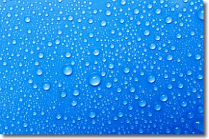
Weather Topic: What is Condensation?
Home - Education - Precipitation - Condensation
 Next Topic: Contrails
Condensation is the process which creates clouds, and therefore
it is a crucial process in the water cycle.
Condensation is the change of matter from a state of gas into a state of liquid,
and it happens because water molecules release heat into the atmosphere and
become organized into a more closely packed structure, what we might see as
water droplets.
Water is always present in the air around us as a vapor, but it's too small for
us to see. When water undergoes the process of condensation it becomes organized
into visible water droplets. You've probably seen condensation happen before on the
surface of a cold drink!
Next Topic: Contrails
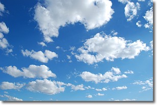
Weather Topic: What are Cumulonimbus Clouds?
Home - Education - Cloud Types - Cumulonimbus Clouds
 Next Topic: Cumulus Clouds
The final form taken by a growing cumulus cloud is the
cumulonimbus cloud, which is very tall and dense.
The tower of a cumulonimbus cloud can soar 23 km into the atmosphere, although
most commonly they stop growing at an altitude of 6 km.
Even small cumulonimbus clouds appear very large in comparison to other cloud types.
They can signal the approach of stormy weather, such as thunderstorms or blizzards.
Next Topic: Cumulus Clouds
Current conditions powered by WeatherAPI.com


