Weather Alert in Texas
Severe Thunderstorm Warning issued August 3 at 1:03PM CDT until August 3 at 2:00PM CDT by NWS Fort Worth TX
AREAS AFFECTED: Collin, TX; Dallas, TX; Denton, TX; Tarrant, TX
DESCRIPTION: SVRFWD The National Weather Service in Fort Worth has issued a * Severe Thunderstorm Warning for... Southeastern Denton County in north central Texas... Eastern Tarrant County in north central Texas... Southwestern Collin County in north central Texas... Northwestern Dallas County in north central Texas... * Until 200 PM CDT. * At 103 PM CDT, a severe thunderstorm was located near Grapevine, moving southeast at 20 mph. HAZARD...60 mph wind gusts and penny size hail. SOURCE...Radar indicated. IMPACT...Expect damage to roofs, siding, and trees. * This severe thunderstorm will be near... Dallas, Irving, Grapevine, Coppell, Southlake, and DFW Intl Airport around 110 PM CDT. Euless around 115 PM CDT. Grand Prairie around 130 PM CDT. Cockrell Hill around 145 PM CDT. Other locations impacted by this severe thunderstorm include White Rock Lake, Joe Pool Lake, Mountain Creek Lake, Buckingham, Grapevine Lake, Lewisville Lake, and Westlake. This includes the following highways... Interstate 35E between mile markers 423 and 454. Interstate 20 between mile markers 451 and 462. Interstate 30 between mile markers 27 and 49. Interstate 45 near mile marker 284.
INSTRUCTION: For your protection get inside a sturdy structure and stay away from windows. Continuous cloud to ground lightning is occurring with this storm. Move indoors immediately. Lightning can kill. Heavy rainfall is occurring with this storm, and may lead to flash flooding. Do not drive your vehicle through flooded roadways.
Want more detail? Get the Complete 7 Day and Night Detailed Forecast!
Current U.S. National Radar--Current
The Current National Weather Radar is shown below with a UTC Time (subtract 5 hours from UTC to get Eastern Time).

National Weather Forecast--Current
The Current National Weather Forecast and National Weather Map are shown below.

National Weather Forecast for Tomorrow
Tomorrow National Weather Forecast and Tomorrow National Weather Map are show below.

North America Water Vapor (Moisture)
This map shows recent moisture content over North America. Bright and colored areas show high moisture (ie, clouds); brown indicates very little moisture present; black indicates no moisture.

Weather Topic: What is Drizzle?
Home - Education - Precipitation - Drizzle
 Next Topic: Evaporation
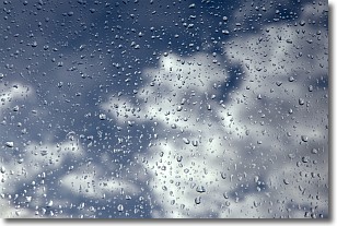
Drizzle is precipitation in the form of water droplets which are
smaller than raindrops.
Drizzle is characterized by fine, gently falling droplets and typically does not
impact human habitation in a negative way. The exception to this is freezing drizzle,
a condition where drizzle freezes immediately upon reaching earth's surface.
Freezing drizzle is still less dangerous than freezing rain, but can
potentially result in hazardous road conditions.
Next Topic: Evaporation
Weather Topic: What is Fog?
Home - Education - Cloud Types - Fog
 Next Topic: Fractus Clouds
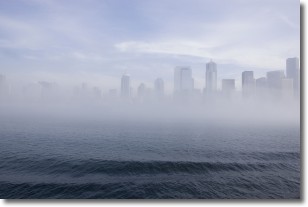
Fog is technically a type of stratus cloud, which lies along the
ground and obscures visibility.
It is usually created when humidity in the air condenses into tiny water droplets.
Because of this, some places are more prone to foggy weather, such as regions
close to a body of water.
Fog is similar to mist; both are the appearance of water droplets suspended in
the air, but fog is the term applied to the condition when visibility is less than 1 km.
Next Topic: Fractus Clouds
Current conditions powered by WeatherAPI.com


