Weather Alert in Maine
Coastal Flood Statement issued August 22 at 1:23AM EDT until August 23 at 12:00AM EDT by NWS Caribou ME
AREAS AFFECTED: Coastal Hancock; Coastal Washington
DESCRIPTION: * WHAT...Waves building to 7 to 10 feet, with a wave period of 13 to 17 seconds. Minor splashover is possible at high tide Friday night. * WHERE...Coastal Hancock and Coastal Washington Counties. * WHEN...For the High Surf Advisory, from 6 PM this evening to 2 PM EDT Saturday. For the Coastal Flood Statement, Friday evening at high tide. * IMPACTS...Rip currents and sneaker waves will lead to dangerous beach conditions. Some minor beach erosion is possible. Minor splashover possible during high tide Friday Evening. SHORELINE FLOOD IMPACTS...Building waves will cause minor splash-over on exposed coastal roads and shorelines. Pedestrians and motorists should use caution along shorelines. Large waves can present a danger to people on rocks above the water. Stay away from rock outcrops along the shoreline exposed to ocean waves...as waves can easily sweep people into the cold ocean water.
INSTRUCTION: A High Surf Advisory Means That High Surf Will Affect Beaches In The Advisory area...producing rip currents and localized beach erosion.
Want more detail? Get the Complete 7 Day and Night Detailed Forecast!
Current U.S. National Radar--Current
The Current National Weather Radar is shown below with a UTC Time (subtract 5 hours from UTC to get Eastern Time).

National Weather Forecast--Current
The Current National Weather Forecast and National Weather Map are shown below.

National Weather Forecast for Tomorrow
Tomorrow National Weather Forecast and Tomorrow National Weather Map are show below.

North America Water Vapor (Moisture)
This map shows recent moisture content over North America. Bright and colored areas show high moisture (ie, clouds); brown indicates very little moisture present; black indicates no moisture.

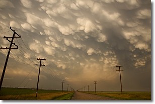
Weather Topic: What are Mammatus Clouds?
Home - Education - Cloud Types - Mammatus Clouds
 Next Topic: Nimbostratus Clouds
A mammatus cloud is a cloud with a unique feature which resembles
a web of pouches hanging along the base of the cloud.
In the United States, mammatus clouds tend to form in the warmer months, commonly
in the Midwest and eastern regions.
While they usually form at the bottom of a cumulonimbis cloud, they can also form
under altostratus, altocumulus, stratocumulus, and cirrus clouds. Mammatus clouds
warn that severe weather is close.
Next Topic: Nimbostratus Clouds
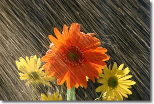
Weather Topic: What is Precipitation?
Home - Education - Precipitation - Precipitation
 Next Topic: Rain
Precipitation can refer to many different forms of water that
may fall from clouds. Precipitation occurs after a cloud has become saturated to
the point where its water particles are more dense than the air below the cloud.
In most cases, precipitation will reach the ground, but it is not uncommon for
precipitation to evaporate before it reaches the earth's surface.
When precipitation evaporates before it contacts the ground it is called Virga.
Graupel, hail, sleet, rain, drizzle, and snow are forms of precipitation, but fog
and mist are not considered precipitation because the water vapor which
constitutes them isn't dense enough to fall to the ground.
Next Topic: Rain
Current conditions powered by WeatherAPI.com


