Weather Alert in Texas
Blowing Dust Advisory issued May 14 at 12:08AM MDT until May 14 at 9:00PM MDT by NWS El Paso Tx/Santa Teresa NM
AREAS AFFECTED: Salt Basin; Rio Grande Valley of Eastern El Paso/Western Hudspeth Counties
DESCRIPTION: * WHAT...Visibility between one quarter mile and one mile in blowing dust expected. West wind gusts 30 to 40 mph. * WHERE...Salt Basin and Rio Grande Valley of Eastern El Paso/Western Hudspeth Counties. * WHEN...From 11 AM this morning to 9 PM MDT this evening. * IMPACTS...Hazardous driving conditions due to reduced visibility.
INSTRUCTION: Motorists should not drive into an area of blowing dust. Remember, Pull Aside, Stay Alive.
Want more detail? Get the Complete 7 Day and Night Detailed Forecast!
Current U.S. National Radar--Current
The Current National Weather Radar is shown below with a UTC Time (subtract 5 hours from UTC to get Eastern Time).

National Weather Forecast--Current
The Current National Weather Forecast and National Weather Map are shown below.

National Weather Forecast for Tomorrow
Tomorrow National Weather Forecast and Tomorrow National Weather Map are show below.

North America Water Vapor (Moisture)
This map shows recent moisture content over North America. Bright and colored areas show high moisture (ie, clouds); brown indicates very little moisture present; black indicates no moisture.

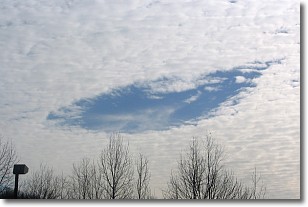
Weather Topic: What are Hole Punch Clouds?
Home - Education - Cloud Types - Hole Punch Clouds
 Next Topic: Mammatus Clouds
A hole punch cloud is an unusual occurrence when a disk-shaped
hole appears in a cirrostratus, cirrocumulus, or altocumulus cloud.
When part of the cloud forms ice crystals, water droplets in the surrounding area
of the cloud evaporate. The effect of this process produces a large elliptical
gap in the cloud. The hole punch cloud formation is rare, but it is not specific
to any geographic area.
Other names which have been used to describe this phenomena include fallstreak hole,
skypunch, and cloud hole.
Next Topic: Mammatus Clouds
Weather Topic: What are Nimbostratus Clouds?
Home - Education - Cloud Types - Nimbostratus Clouds
 Next Topic: Precipitation
A nimbostratus cloud is similar to a stratus cloud in its formless,
smooth appearance. However, a nimbostratus cloud is darker than a stratus cloud,
because it is thicker.
Unlike a stratus cloud, a nimbostratus cloud typically brings with it the threat
of moderate to heavy precipitation. In some cases, the precipitation may evaporate
before reaching the ground, a phenomenon known as virga.
Next Topic: Precipitation
Current conditions powered by WeatherAPI.com


