Weather Alert in Indiana
Flood Warning issued March 4 at 3:57AM EST until March 8 at 10:35PM EDT by NWS Indianapolis IN
AREAS AFFECTED: Bartholomew, IN; Johnson, IN; Shelby, IN
DESCRIPTION: ...The National Weather Service in Indianapolis IN has issued a Flood Warning for the following rivers in Indiana... Big Blue River at Shelbyville. Driftwood River near Edinburgh. Flatrock River near Columbus. East Fork White River at Columbus. White River at Spencer. Eel River at Bowling Green. ...Forecast flooding changed from Minor to Moderate severity and increased in duration for the following rivers in Indiana... East Fork White River at Seymour. .Between 2 and 4 inches of rain have fallen across central Indiana as of early Wednesday morning. Up to 2 inches have fallen in south-central Indiana. This has led creeks to rise above flood stage and rivers will follow in the coming days. Additional rain is in the forecast over the next several days. * WHAT...Minor flooding is forecast. * WHERE...Driftwood River near Edinburgh. * WHEN...From this evening to late Sunday evening. * IMPACTS...At 14.0 feet, Extensive flooding along Big Blue River in Edinburgh area. In Johnson County CR 650S between CR 700E and CR 800E flooded. Water approaching or on CR 700E near CR 775S. Irwin Park in Edinburgh extensively flooded. Water affecting one residence in Shelby County at CR 900W and CR 1000S. * ADDITIONAL DETAILS... - At 2:30 AM EST Wednesday the stage was 7.1 feet. - Forecast...The river will rise above flood stage late this evening to 13.8 feet early Friday afternoon. It will then fall below flood stage late Sunday morning. - Flood stage is 11.0 feet. - http://www.weather.gov/safety/flood
INSTRUCTION: Motorists should not attempt to drive around barricades or drive cars through flooded areas. Additional information is available at www.weather.gov/ind. The next statement should be issued this evening by around 700 PM EST.
Want more detail? Get the Complete 7 Day and Night Detailed Forecast!
Current U.S. National Radar--Current
The Current National Weather Radar is shown below with a UTC Time (subtract 5 hours from UTC to get Eastern Time).

National Weather Forecast--Current
The Current National Weather Forecast and National Weather Map are shown below.

National Weather Forecast for Tomorrow
Tomorrow National Weather Forecast and Tomorrow National Weather Map are show below.

North America Water Vapor (Moisture)
This map shows recent moisture content over North America. Bright and colored areas show high moisture (ie, clouds); brown indicates very little moisture present; black indicates no moisture.

Weather Topic: What is Hail?
Home - Education - Precipitation - Hail
 Next Topic: Hole Punch Clouds
Hail is a form of precipitation which is recognized by large solid balls or
clumps of ice. Hail is created by thunderstorm clouds with strong updrafts of wind.
As the hailstones remain in the updraft, ice is deposited onto them until their
weight becomes heavy enough for them to fall to the earth's surface.
Hail storms can cause significant damage to crops, aircrafts, and man-made structures,
despite the fact that the duration is usually less than ten minutes.
Next Topic: Hole Punch Clouds
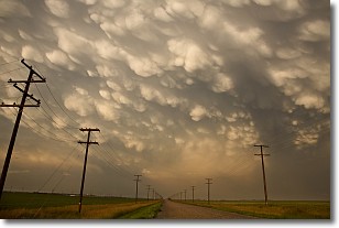
Weather Topic: What are Mammatus Clouds?
Home - Education - Cloud Types - Mammatus Clouds
 Next Topic: Nimbostratus Clouds
A mammatus cloud is a cloud with a unique feature which resembles
a web of pouches hanging along the base of the cloud.
In the United States, mammatus clouds tend to form in the warmer months, commonly
in the Midwest and eastern regions.
While they usually form at the bottom of a cumulonimbis cloud, they can also form
under altostratus, altocumulus, stratocumulus, and cirrus clouds. Mammatus clouds
warn that severe weather is close.
Next Topic: Nimbostratus Clouds
Current conditions powered by WeatherAPI.com


