Weather Alert in Colorado
Special Weather Statement issued June 15 at 2:57PM MDT by NWS Denver CO
AREAS AFFECTED: North Douglas County Below 6000 Feet/Denver/West Adams and Arapahoe Counties/East Broomfield County; Elbert/Central and East Douglas Counties Above 6000 Feet; Central and East Adams and Arapahoe Counties
DESCRIPTION: At 257 PM MDT, Doppler radar was tracking a strong thunderstorm over Arapahoe Park, or 17 miles southeast of Denver, moving northeast at 15 mph. HAZARD...Wind gusts of 50 to 55 mph. SOURCE...Radar indicated. IMPACT...Gusty winds could knock down tree limbs and blow around unsecured objects. Locations impacted include... Aurora, eastern Centennial, northwestern Parker, Bennett, Arapahoe Park, Watkins, Buckley SFB, Manila Village and Foxfield.
INSTRUCTION: Monitor the weather situation closely and be alert for threatening weather conditions. If on or near a lake, get out of the water and move indoors or inside a vehicle. Remember, lightning can strike out to 10 miles from the parent thunderstorm. If you can hear thunder, you are close enough to be struck by lightning. Move to safe shelter now! Do not be caught on the water in a thunderstorm.
Want more detail? Get the Complete 7 Day and Night Detailed Forecast!
Current U.S. National Radar--Current
The Current National Weather Radar is shown below with a UTC Time (subtract 5 hours from UTC to get Eastern Time).

National Weather Forecast--Current
The Current National Weather Forecast and National Weather Map are shown below.

National Weather Forecast for Tomorrow
Tomorrow National Weather Forecast and Tomorrow National Weather Map are show below.

North America Water Vapor (Moisture)
This map shows recent moisture content over North America. Bright and colored areas show high moisture (ie, clouds); brown indicates very little moisture present; black indicates no moisture.

Weather Topic: What is Drizzle?
Home - Education - Precipitation - Drizzle
 Next Topic: Evaporation
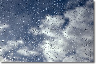
Drizzle is precipitation in the form of water droplets which are
smaller than raindrops.
Drizzle is characterized by fine, gently falling droplets and typically does not
impact human habitation in a negative way. The exception to this is freezing drizzle,
a condition where drizzle freezes immediately upon reaching earth's surface.
Freezing drizzle is still less dangerous than freezing rain, but can
potentially result in hazardous road conditions.
Next Topic: Evaporation
Weather Topic: What is Fog?
Home - Education - Cloud Types - Fog
 Next Topic: Fractus Clouds
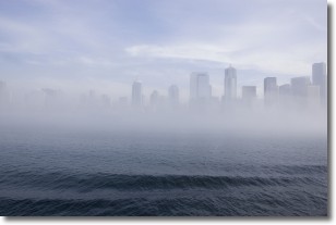
Fog is technically a type of stratus cloud, which lies along the
ground and obscures visibility.
It is usually created when humidity in the air condenses into tiny water droplets.
Because of this, some places are more prone to foggy weather, such as regions
close to a body of water.
Fog is similar to mist; both are the appearance of water droplets suspended in
the air, but fog is the term applied to the condition when visibility is less than 1 km.
Next Topic: Fractus Clouds
Current conditions powered by WeatherAPI.com


