Weather Alert in North Carolina
Winter Weather Advisory issued February 21 at 1:50PM EST until February 24 at 12:00AM EST by NWS Greenville-Spartanburg SC
AREAS AFFECTED: Mitchell
DESCRIPTION: * WHAT...For the Winter Storm Warning above 3500 feet, heavy snow expected. Total snow accumulations between 5 and 10 inches. For the Winter Weather Advisory below 3500 feet, snow expected. Total snow accumulations between 1 and 4 inches, with higher amounts along the Tennessee border. * WHERE...Mitchell County. * WHEN...From midnight tonight to midnight EST Monday Night. * IMPACTS...The heavy snow will make many roads impassable and may produce a few power outages due to the weight of the snow on tree limbs and power lines. The hazardous conditions could impact the Monday morning and evening commutes. * ADDITIONAL DETAILS...Winds gusting as high as 50 mph could result in areas of blowing snow and very low visibility Sunday night and Monday.
INSTRUCTION: Monitor the latest forecasts for updates on this situation. Slow down and use caution while traveling. If you must travel, keep an extra flashlight, food, and water in your vehicle in case of an emergency. Slow down and use caution while traveling. The latest road conditions for the state you are calling from can be obtained by calling 5 1 1.
Want more detail? Get the Complete 7 Day and Night Detailed Forecast!
Current U.S. National Radar--Current
The Current National Weather Radar is shown below with a UTC Time (subtract 5 hours from UTC to get Eastern Time).

National Weather Forecast--Current
The Current National Weather Forecast and National Weather Map are shown below.

National Weather Forecast for Tomorrow
Tomorrow National Weather Forecast and Tomorrow National Weather Map are show below.

North America Water Vapor (Moisture)
This map shows recent moisture content over North America. Bright and colored areas show high moisture (ie, clouds); brown indicates very little moisture present; black indicates no moisture.

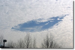
Weather Topic: What are Hole Punch Clouds?
Home - Education - Cloud Types - Hole Punch Clouds
 Next Topic: Mammatus Clouds
A hole punch cloud is an unusual occurrence when a disk-shaped
hole appears in a cirrostratus, cirrocumulus, or altocumulus cloud.
When part of the cloud forms ice crystals, water droplets in the surrounding area
of the cloud evaporate. The effect of this process produces a large elliptical
gap in the cloud. The hole punch cloud formation is rare, but it is not specific
to any geographic area.
Other names which have been used to describe this phenomena include fallstreak hole,
skypunch, and cloud hole.
Next Topic: Mammatus Clouds
Weather Topic: What are Nimbostratus Clouds?
Home - Education - Cloud Types - Nimbostratus Clouds
 Next Topic: Precipitation
A nimbostratus cloud is similar to a stratus cloud in its formless,
smooth appearance. However, a nimbostratus cloud is darker than a stratus cloud,
because it is thicker.
Unlike a stratus cloud, a nimbostratus cloud typically brings with it the threat
of moderate to heavy precipitation. In some cases, the precipitation may evaporate
before reaching the ground, a phenomenon known as virga.
Next Topic: Precipitation
Current conditions powered by WeatherAPI.com


