Weather Alert in Alaska
Flood Warning issued September 1 at 9:34AM AKDT until September 2 at 12:00PM AKDT by NWS Fairbanks AK
AREAS AFFECTED: Upper Koyukuk Valley
DESCRIPTION: * WHAT...Flooding caused by excessive rainfall continues. * WHERE...Koyukuk River near Allakaket. * WHEN...Until noon AKDT Tuesday. * IMPACTS...Flooding of rivers, creeks, streams, and other low-lying and flood-prone locations is occurring. * ADDITIONAL DETAILS... - At 930 AM AKDT, - River levels have continued to come down, but inundation of low lying roads is expected to continue. The streamgage on the Koyukuk River below the John River has shown over a foot of water level drop in the last 12 hours once again. The Middle and South Forks of the Koyukuk are also showing decreasing water levels. Water levels at Allakaket should continue to drop. This is encouraging as an additional 0.50 to 1 inch of rain is forecast for the south slopes of the Brooks Range through Tuesday. - Low lying roads are currently flooded and airport access may be cut off. - http://www.weather.gov/aprfc
INSTRUCTION: N/A
Want more detail? Get the Complete 7 Day and Night Detailed Forecast!
Current U.S. National Radar--Current
The Current National Weather Radar is shown below with a UTC Time (subtract 5 hours from UTC to get Eastern Time).

National Weather Forecast--Current
The Current National Weather Forecast and National Weather Map are shown below.

National Weather Forecast for Tomorrow
Tomorrow National Weather Forecast and Tomorrow National Weather Map are show below.

North America Water Vapor (Moisture)
This map shows recent moisture content over North America. Bright and colored areas show high moisture (ie, clouds); brown indicates very little moisture present; black indicates no moisture.

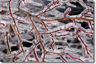
Weather Topic: What is Freezing Rain?
Home - Education - Precipitation - Freezing Rain
 Next Topic: Graupel
Freezing rain is a condition where precipitation which has fallen in the form of
water droplets reaches temperatures which are below freezing and freezes upon
coming into contact
with surface objects. The result of this precipitation is a glaze of ice which
can be damaging to plants and man-made structures. A severe onset of freezing
rain which results in a very thick glaze of ice is known as an ice storm.
Next Topic: Graupel
Weather Topic: What is Hail?
Home - Education - Precipitation - Hail
 Next Topic: Hole Punch Clouds
Hail is a form of precipitation which is recognized by large solid balls or
clumps of ice. Hail is created by thunderstorm clouds with strong updrafts of wind.
As the hailstones remain in the updraft, ice is deposited onto them until their
weight becomes heavy enough for them to fall to the earth's surface.
Hail storms can cause significant damage to crops, aircrafts, and man-made structures,
despite the fact that the duration is usually less than ten minutes.
Next Topic: Hole Punch Clouds
Current conditions powered by WeatherAPI.com


