Weather Alert in Ohio
Air Quality Alert issued June 12 at 12:04AM EDT by NWS Wilmington OH
AREAS AFFECTED: Delaware; Franklin; Licking; Fairfield
DESCRIPTION: The Mid-Ohio Regional Planning Commission has issued an Air Quality Alert for Delaware, Fairfield, Franklin and Licking counties in Central Ohio, from 6 AM this morning to 10 PM EDT this evening. Levels of ozone within the region may approach or exceed unhealthy standards. On Alert days, help reduce ozone by taking the following actions: * Carpool, if possible, bike, walk or take the bus instead of driving alone. * Refuel your vehicle after 8 pm. * Do not idle your vehicle, exhaust contributes to air pollution. * Mow your lawn in the evening hours and avoid the use of gas-powered lawn equipment. For additional information, please visit the Mid-Ohio Regional Planning Commission's website at morpc.org/airquality
INSTRUCTION: N/A
Want more detail? Get the Complete 7 Day and Night Detailed Forecast!
Current U.S. National Radar--Current
The Current National Weather Radar is shown below with a UTC Time (subtract 5 hours from UTC to get Eastern Time).

National Weather Forecast--Current
The Current National Weather Forecast and National Weather Map are shown below.

National Weather Forecast for Tomorrow
Tomorrow National Weather Forecast and Tomorrow National Weather Map are show below.

North America Water Vapor (Moisture)
This map shows recent moisture content over North America. Bright and colored areas show high moisture (ie, clouds); brown indicates very little moisture present; black indicates no moisture.

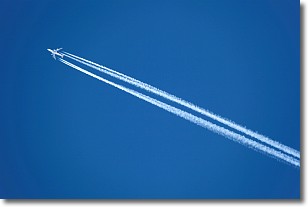
Weather Topic: What are Contrails?
Home - Education - Cloud Types - Contrails
 Next Topic: Cumulonimbus Clouds
A contrail is an artificial cloud, created by the passing of an
aircraft.
Contrails form because water vapor in the exhaust of aircraft engines is suspended
in the air under certain temperatures and humidity conditions. These contrails
are called exhaust contrails.
Another type of contrail can form due to a temporary reduction in air pressure
moving over the plane's surface, causing condensation.
These are called aerodynamic contrails.
When you can see your breath on a cold day, it is also because of condensation.
The reason contrails last longer than the condensation from your breath is
because the water in contrails freezes into ice particles.
Next Topic: Cumulonimbus Clouds
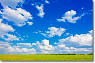
Weather Topic: What are Cumulus Clouds?
Home - Education - Cloud Types - Cumulus Clouds
 Next Topic: Drizzle
Cumulus clouds are fluffy and textured with rounded tops, and
may have flat bottoms. The border of a cumulus cloud
is clearly defined, and can have the appearance of cotton or cauliflower.
Cumulus clouds form at low altitudes (rarely above 2 km) but can grow very tall,
becoming cumulus congestus and possibly the even taller cumulonimbus clouds.
When cumulus clouds become taller, they have a greater chance of producing precipitation.
Next Topic: Drizzle
Current conditions powered by WeatherAPI.com


