Weather Alert in Arizona
Severe Thunderstorm Warning issued August 25 at 5:27PM MST until August 25 at 6:15PM MST by NWS Phoenix AZ
AREAS AFFECTED: Maricopa, AZ
DESCRIPTION: SVRPSR The National Weather Service in Phoenix has issued a * Severe Thunderstorm Warning for... Maricopa County in south central Arizona... * Until 615 PM MST. * At 526 PM MST, a severe thunderstorm was located over Queen Creek, or 7 miles southeast of Gilbert, moving northwest at 15 mph. HAZARD...60 mph wind gusts. SOURCE...Radar indicated. IMPACT...Expect damage to roofs, siding, and trees. * Locations impacted include... Mesa, Chandler, Gilbert, Tempe, Gilbert City Hall, Downtown Mesa, Tumbleweed Park, Chandler City Hall, San Tan Village Mall, Freestone Park, Fiesta Mall, Phoenix Mesa Gateway Airport, and Higley. This includes the following highways... US Highway 60 between mile markers 178 and 188. AZ Route 87 between mile markers 164 and 173. AZ Route 202 between mile markers 35 and 49.
INSTRUCTION: For your protection move to an interior room on the lowest floor of a building.
Want more detail? Get the Complete 7 Day and Night Detailed Forecast!
Current U.S. National Radar--Current
The Current National Weather Radar is shown below with a UTC Time (subtract 5 hours from UTC to get Eastern Time).

National Weather Forecast--Current
The Current National Weather Forecast and National Weather Map are shown below.

National Weather Forecast for Tomorrow
Tomorrow National Weather Forecast and Tomorrow National Weather Map are show below.

North America Water Vapor (Moisture)
This map shows recent moisture content over North America. Bright and colored areas show high moisture (ie, clouds); brown indicates very little moisture present; black indicates no moisture.

Weather Topic: What is Hail?
Home - Education - Precipitation - Hail
 Next Topic: Hole Punch Clouds
Hail is a form of precipitation which is recognized by large solid balls or
clumps of ice. Hail is created by thunderstorm clouds with strong updrafts of wind.
As the hailstones remain in the updraft, ice is deposited onto them until their
weight becomes heavy enough for them to fall to the earth's surface.
Hail storms can cause significant damage to crops, aircrafts, and man-made structures,
despite the fact that the duration is usually less than ten minutes.
Next Topic: Hole Punch Clouds
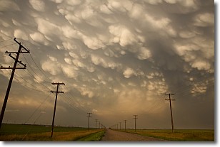
Weather Topic: What are Mammatus Clouds?
Home - Education - Cloud Types - Mammatus Clouds
 Next Topic: Nimbostratus Clouds
A mammatus cloud is a cloud with a unique feature which resembles
a web of pouches hanging along the base of the cloud.
In the United States, mammatus clouds tend to form in the warmer months, commonly
in the Midwest and eastern regions.
While they usually form at the bottom of a cumulonimbis cloud, they can also form
under altostratus, altocumulus, stratocumulus, and cirrus clouds. Mammatus clouds
warn that severe weather is close.
Next Topic: Nimbostratus Clouds
Current conditions powered by WeatherAPI.com


