Weather Alert in Arizona
Extreme Heat Warning issued June 13 at 12:08AM MST until June 16 at 8:00PM MST by NWS Phoenix AZ
AREAS AFFECTED: Northwest Valley; Buckeye/Avondale; Cave Creek/New River; Deer Valley; Central Phoenix; North Phoenix/Glendale; Scottsdale/Paradise Valley; East Valley; Fountain Hills/East Mesa; South Mountain/Ahwatukee; Southeast Valley/Queen Creek
DESCRIPTION: * WHAT...Dangerously hot conditions. Afternoon temperatures 105 to 114 expected. Major Heat Risk. Overexposure can cause heat cramps and heat exhaustion to develop and, without intervention, can lead to heat stroke. * WHERE...A portion of south central Arizona, including the Phoenix Metro. * WHEN...From 10 AM Saturday to 8 PM MST Monday. * IMPACTS...Heat related illnesses increase significantly during extreme heat events. * ADDITIONAL DETAILS...In Maricopa County, call 2 1 1 to find a free cooling center, transportation, water, and more. https://www.maricopa.gov/heat
INSTRUCTION: An Extreme Heat Warning means that a period of very hot temperatures, even by local standards, will occur. Actions should be taken to lessen the impact of the extreme heat. Take extra precautions if you work or spend time outside. When possible, reschedule strenuous activities to early morning or evening. Know the signs and symptoms of heat exhaustion and heat stroke. Wear lightweight and loose-fitting clothing when possible and drink plenty of water. To reduce risk during outdoor work, the Occupational Safety and Health Administration recommends scheduling frequent rest breaks in shaded or air conditioned environments. Anyone overcome by heat should be moved to a cool and shaded location. Heat stroke is an emergency! Call 9 1 1. Public cooling shelters are available in some areas. Consult county officials for more details.
Want more detail? Get the Complete 7 Day and Night Detailed Forecast!
Current U.S. National Radar--Current
The Current National Weather Radar is shown below with a UTC Time (subtract 5 hours from UTC to get Eastern Time).

National Weather Forecast--Current
The Current National Weather Forecast and National Weather Map are shown below.

National Weather Forecast for Tomorrow
Tomorrow National Weather Forecast and Tomorrow National Weather Map are show below.

North America Water Vapor (Moisture)
This map shows recent moisture content over North America. Bright and colored areas show high moisture (ie, clouds); brown indicates very little moisture present; black indicates no moisture.

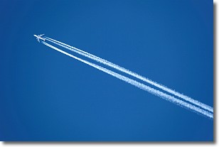
Weather Topic: What are Contrails?
Home - Education - Cloud Types - Contrails
 Next Topic: Cumulonimbus Clouds
A contrail is an artificial cloud, created by the passing of an
aircraft.
Contrails form because water vapor in the exhaust of aircraft engines is suspended
in the air under certain temperatures and humidity conditions. These contrails
are called exhaust contrails.
Another type of contrail can form due to a temporary reduction in air pressure
moving over the plane's surface, causing condensation.
These are called aerodynamic contrails.
When you can see your breath on a cold day, it is also because of condensation.
The reason contrails last longer than the condensation from your breath is
because the water in contrails freezes into ice particles.
Next Topic: Cumulonimbus Clouds
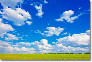
Weather Topic: What are Cumulus Clouds?
Home - Education - Cloud Types - Cumulus Clouds
 Next Topic: Drizzle
Cumulus clouds are fluffy and textured with rounded tops, and
may have flat bottoms. The border of a cumulus cloud
is clearly defined, and can have the appearance of cotton or cauliflower.
Cumulus clouds form at low altitudes (rarely above 2 km) but can grow very tall,
becoming cumulus congestus and possibly the even taller cumulonimbus clouds.
When cumulus clouds become taller, they have a greater chance of producing precipitation.
Next Topic: Drizzle
Current conditions powered by WeatherAPI.com


