Weather Alert in West Virginia
Winter Storm Warning issued February 21 at 12:24PM EST until February 24 at 1:00AM EST by NWS Charleston WV
AREAS AFFECTED: Clay; Braxton; Lewis; Taylor; Upshur; Barbour; Northwest Raleigh; Southeast Raleigh; Northwest Fayette; Southeast Fayette; Northwest Nicholas; Southeast Nicholas; Northwest Webster; Southeast Webster; Northwest Pocahontas; Northwest Randolph; Southeast Randolph
DESCRIPTION: * WHAT...Heavy snow expected. Total snow accumulations between 5 and 12 inches. Winds gusting as high as 45 mph. * WHERE...Portions of central, northeast, northern, and southeast West Virginia. * WHEN...From 1 AM Sunday to 1 AM EST Tuesday. * IMPACTS...Roads, and especially bridges and overpasses, will likely become slick and hazardous. Whiteout conditions are expected and will make travel treacherous and potentially life-threatening. Travel could be very difficult to impossible. The hazardous conditions could impact the Monday morning and evening commutes. Gusty winds could bring down tree branches.
INSTRUCTION: If you must travel, keep an extra flashlight, food, and water in your vehicle in case of an emergency. The latest road conditions for the state you are calling from can be obtained by calling 5 1 1 or by accessing the online traffic and roadway portal for your state. Persons should consider delaying all travel. If travel is absolutely necessary, drive with extreme caution. Consider taking a winter storm kit along with you, including such items as tire chains, booster cables, flashlight, shovel, blankets and extra clothing. Also take water, a first aid kit, and anything else that would help you survive in case you become stranded. Additional information can be found at https://www.weather.gov/rlx as well as on our X and Facebook pages.
Want more detail? Get the Complete 7 Day and Night Detailed Forecast!
Current U.S. National Radar--Current
The Current National Weather Radar is shown below with a UTC Time (subtract 5 hours from UTC to get Eastern Time).

National Weather Forecast--Current
The Current National Weather Forecast and National Weather Map are shown below.

National Weather Forecast for Tomorrow
Tomorrow National Weather Forecast and Tomorrow National Weather Map are show below.

North America Water Vapor (Moisture)
This map shows recent moisture content over North America. Bright and colored areas show high moisture (ie, clouds); brown indicates very little moisture present; black indicates no moisture.

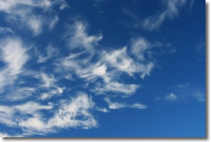
Weather Topic: What are Cirrostratus Clouds?
Home - Education - Cloud Types - Cirrostratus Clouds
 Next Topic: Cirrus Clouds
Cirrostratus clouds are high, thin clouds that form above
20,000 feet and are made mostly of ice crystals. They sometimes look like giant
feathers, horse tails, or curls of hair in the sky.
These clouds are pushed by the jet stream and can move at high speeds reaching
100 mph.
What do they indicate?
They indicate that a precipitation is likely within 24 hours.
Next Topic: Cirrus Clouds
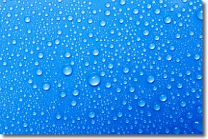
Weather Topic: What is Condensation?
Home - Education - Precipitation - Condensation
 Next Topic: Contrails
Condensation is the process which creates clouds, and therefore
it is a crucial process in the water cycle.
Condensation is the change of matter from a state of gas into a state of liquid,
and it happens because water molecules release heat into the atmosphere and
become organized into a more closely packed structure, what we might see as
water droplets.
Water is always present in the air around us as a vapor, but it's too small for
us to see. When water undergoes the process of condensation it becomes organized
into visible water droplets. You've probably seen condensation happen before on the
surface of a cold drink!
Next Topic: Contrails
Current conditions powered by WeatherAPI.com


