Weather Alert in Arizona
Winter Storm Warning issued February 18 at 5:17AM MST until February 18 at 8:00PM MST by NWS Flagstaff AZ
AREAS AFFECTED: Kaibab Plateau; Western Mogollon Rim; Eastern Mogollon Rim
DESCRIPTION: * WHAT...For the Winter Storm Warning, heavy snow expected along with blowing snow. Total snow accumulations between 4 to 10 inches. Winds gusting as high as 65 mph. For the Winter Storm Watch, heavy snow possible. Total snow accumulations between 3 and 9 inches possible. Winds could gust as high as 45 mph. * WHERE...Mogollon Rim, and Kaibab Plateau. * WHEN...For the Winter Storm Warning, until 8 PM MST this evening. For the Winter Storm Watch, from Thursday afternoon through Friday morning. * IMPACTS...Roads, and especially bridges and overpasses, will likely become slick and hazardous. Travel is not recommended as heavy snowfall and low visibility will create dangerous driving conditions. Widespread blowing snow could significantly reduce visibility. The hazardous conditions will impact the Wednesday morning and evening commutes. Very strong winds could cause extensive damage to trees and power lines. Roads, and especially bridges and overpasses, will likely become slick and hazardous. * ADDITIONAL DETAILS... Forecast snowfall amounts from 5 AM MST Today to 8 PM MST Today... Forest Lakes: 6 to 8" Fredonia: 1 to 2" Doney Park: 4 to 6" Flagstaff: 6 to 8" Munds Park: 6 to 10" Pine-Strawberry: 4 to 6" Williams: 5 to 8" Heber-Overgaard: 1 to 2" Jacob Lake: 6 to 8"
INSTRUCTION: If you must travel, keep an extra flashlight, food, and water in your vehicle in case of an emergency. For the latest road conditions and closures go to az511.gov, or call 5 1 1. Persons should consider delaying all travel. Motorists should use extreme caution if travel is absolutely necessary. Monitor the latest forecasts for updates on this situation.
Want more detail? Get the Complete 7 Day and Night Detailed Forecast!
Current U.S. National Radar--Current
The Current National Weather Radar is shown below with a UTC Time (subtract 5 hours from UTC to get Eastern Time).

National Weather Forecast--Current
The Current National Weather Forecast and National Weather Map are shown below.

National Weather Forecast for Tomorrow
Tomorrow National Weather Forecast and Tomorrow National Weather Map are show below.

North America Water Vapor (Moisture)
This map shows recent moisture content over North America. Bright and colored areas show high moisture (ie, clouds); brown indicates very little moisture present; black indicates no moisture.

Weather Topic: What are Altostratus Clouds?
Home - Education - Cloud Types - Altostratus Clouds
 Next Topic: Cirrocumulus Clouds
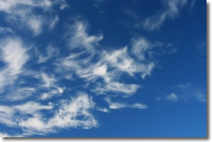
Altostratus clouds form at mid to high-level altitudes
(between 2 and 7 km) and are created by a warm, stable air mass which causes
water vapor
to condense as it rise through the atmosphere. Usually altostratus clouds are
featureless sheets characterized by a uniform color.
In some cases, wind punching through the cloud formation may give it a waved
appearance, called altostratus undulatus. Altostratus clouds
are commonly seen with other cloud formations accompanying them.
Next Topic: Cirrocumulus Clouds
Weather Topic: What are Cirrostratus Clouds?
Home - Education - Cloud Types - Cirrostratus Clouds
 Next Topic: Cirrus Clouds
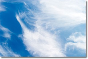
Cirrostratus clouds are high, thin clouds that form above
20,000 feet and are made mostly of ice crystals. They sometimes look like giant
feathers, horse tails, or curls of hair in the sky.
These clouds are pushed by the jet stream and can move at high speeds reaching
100 mph.
What do they indicate?
They indicate that a precipitation is likely within 24 hours.
Next Topic: Cirrus Clouds
Current conditions powered by WeatherAPI.com


