Weather Alert in Oregon
Winter Weather Advisory issued March 4 at 9:33AM PST until March 5 at 4:00AM PST by NWS Portland OR
AREAS AFFECTED: Cascades of Marion and Linn Counties; Cascades of Lane County
DESCRIPTION: * WHAT...Snow above 4000 ft. Additional snow accumulations up to 9 to 11 inches at Santiam and Willamette Passes. Winds gusting as high as 35 mph. * WHERE...Cascades of Lane County and Cascades of Marion and Linn Counties. * WHEN...Until 4 AM PST Thursday. * IMPACTS...Roads, and especially bridges and overpasses, will likely become slick and hazardous. Periods of moderate to heavy snowfall combined with low visibilities may create difficult driving conditions. * ADDITIONAL DETAILS...Fairly uniform snow late Wednesday morning will transition to showers in the afternoon. Heaviest snowfall rates are expected between now and 6 PM Wednesday.
INSTRUCTION: Be prepared for slippery roads. Slow down and use caution while driving. If you are going outside, watch your first few steps taken on stairs, sidewalks, and driveways. These surfaces could be slippery, increasing your risk of a fall and injury. Have a winter emergency driving kit readily available. Common items to include: flashlight, batteries, blankets, a shovel, water, non-perishable food items, tire chains, etc. For the latest road conditions and chain restrictions in Oregon, call 5 1 1, or visit: www.tripcheck.com. For the latest road conditions and chain restrictions in Washington, visit: wsdot.com/travel/real-time/map
Want more detail? Get the Complete 7 Day and Night Detailed Forecast!
Current U.S. National Radar--Current
The Current National Weather Radar is shown below with a UTC Time (subtract 5 hours from UTC to get Eastern Time).

National Weather Forecast--Current
The Current National Weather Forecast and National Weather Map are shown below.

National Weather Forecast for Tomorrow
Tomorrow National Weather Forecast and Tomorrow National Weather Map are show below.

North America Water Vapor (Moisture)
This map shows recent moisture content over North America. Bright and colored areas show high moisture (ie, clouds); brown indicates very little moisture present; black indicates no moisture.

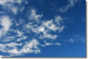
Weather Topic: What are Cirrostratus Clouds?
Home - Education - Cloud Types - Cirrostratus Clouds
 Next Topic: Cirrus Clouds
Cirrostratus clouds are high, thin clouds that form above
20,000 feet and are made mostly of ice crystals. They sometimes look like giant
feathers, horse tails, or curls of hair in the sky.
These clouds are pushed by the jet stream and can move at high speeds reaching
100 mph.
What do they indicate?
They indicate that a precipitation is likely within 24 hours.
Next Topic: Cirrus Clouds
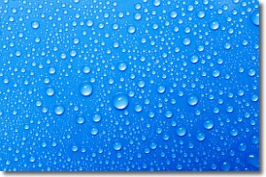
Weather Topic: What is Condensation?
Home - Education - Precipitation - Condensation
 Next Topic: Contrails
Condensation is the process which creates clouds, and therefore
it is a crucial process in the water cycle.
Condensation is the change of matter from a state of gas into a state of liquid,
and it happens because water molecules release heat into the atmosphere and
become organized into a more closely packed structure, what we might see as
water droplets.
Water is always present in the air around us as a vapor, but it's too small for
us to see. When water undergoes the process of condensation it becomes organized
into visible water droplets. You've probably seen condensation happen before on the
surface of a cold drink!
Next Topic: Contrails
Current conditions powered by WeatherAPI.com


