Weather Alert in Alaska
Heat Advisory issued August 23 at 4:26AM AKDT until August 24 at 7:00PM AKDT by NWS Juneau AK
AREAS AFFECTED: City of Hyder
DESCRIPTION: * WHAT...Temperatures up to around 80 degrees expected. * WHERE...City of Hyder. * WHEN...From noon Saturday to 7 PM AKDT Sunday. * IMPACTS...Individuals not accustomed to these unusually warm temperatures for this region may experience heat related illnesses. * ADDITIONAL DETAILS...Warm temperatures are expected Saturday, reaching into the high 70s to low 80s. Warm temperatures will continue through the rest of the weekend and into the start of next week. Even though the advisory lasts through Sunday, warmest temperatures will be noon into the evening hours with nighttime temperatures in the 60s. Expect the warmest temperatures to be over inland areas.
INSTRUCTION: Drink plenty of fluids and check up on elderly and vulnerable relatives and neighbors. Young children and pets should never be left unattended in vehicles under any circumstances as vehicle interiors can reach extreme temperatures in as little as 10 minutes Take extra precautions when working in the sun. Wear sunscreen and lightweight, loose fitting clothing. Try to limit strenuous activities to early morning or evening. Take action when you see symptoms of heat exhaustion and heat stroke Close curtains during the daytime to reduce sun insulation into the home and open windows at night to allow the home to cool off. Utilize fans or community buildings with air conditioning.
Want more detail? Get the Complete 7 Day and Night Detailed Forecast!
Current U.S. National Radar--Current
The Current National Weather Radar is shown below with a UTC Time (subtract 5 hours from UTC to get Eastern Time).

National Weather Forecast--Current
The Current National Weather Forecast and National Weather Map are shown below.

National Weather Forecast for Tomorrow
Tomorrow National Weather Forecast and Tomorrow National Weather Map are show below.

North America Water Vapor (Moisture)
This map shows recent moisture content over North America. Bright and colored areas show high moisture (ie, clouds); brown indicates very little moisture present; black indicates no moisture.

Weather Topic: What is Hail?
Home - Education - Precipitation - Hail
 Next Topic: Hole Punch Clouds
Hail is a form of precipitation which is recognized by large solid balls or
clumps of ice. Hail is created by thunderstorm clouds with strong updrafts of wind.
As the hailstones remain in the updraft, ice is deposited onto them until their
weight becomes heavy enough for them to fall to the earth's surface.
Hail storms can cause significant damage to crops, aircrafts, and man-made structures,
despite the fact that the duration is usually less than ten minutes.
Next Topic: Hole Punch Clouds
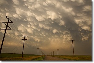
Weather Topic: What are Mammatus Clouds?
Home - Education - Cloud Types - Mammatus Clouds
 Next Topic: Nimbostratus Clouds
A mammatus cloud is a cloud with a unique feature which resembles
a web of pouches hanging along the base of the cloud.
In the United States, mammatus clouds tend to form in the warmer months, commonly
in the Midwest and eastern regions.
While they usually form at the bottom of a cumulonimbis cloud, they can also form
under altostratus, altocumulus, stratocumulus, and cirrus clouds. Mammatus clouds
warn that severe weather is close.
Next Topic: Nimbostratus Clouds
Current conditions powered by WeatherAPI.com


