Weather Alerts for Colorado
1. Fire Weather Watch for: Elbert/Central and East Douglas Counties Above 6000 Feet; Central and East Adams and Arapahoe Counties; North and Northeast Elbert County Below 6000 Feet/North Lincoln County; Southeast Elbert County Below 6000 Feet/South Lincoln County
2. Fire Weather Watch for: Fremont County Including Canon City/Howard/Texas Creek; San Luis Valley Including Alamosa/Del Norte/Fort Garland/Saguache; Northern El Paso County Including Monument and Black Forest; Southern El Paso County Including Fort Carson and Colorado Springs; Pueblo County Including Pueblo; Huerfano County Including Walsenburg; Western Las Animas County Including Trinidad and Thatcher; Crowley County Including Ordway; Otero County Including La Junta and Western Comanche Grasslands; Eastern Las Animas County Including Pinon Canyon; Kiowa County Including Eads; Bent County Including Las Animas; Prowers County Including Lamar; Baca County Including Springfield and Eastern Comanche Grasslands
3. Fire Weather Watch for: Kit Carson County; Cheyenne
4. Fire Weather Watch for: Southern Front Range Including Sangre De Cristo Mountains/Wet Mountains/La Veta Pass
Want more detail? Get the Complete 7 Day and Night Detailed Forecast!
Current U.S. National Radar--Current
The Current National Weather Radar is shown below with a UTC Time (subtract 5 hours from UTC to get Eastern Time).

National Weather Forecast--Current
The Current National Weather Forecast and National Weather Map are shown below.

National Weather Forecast for Tomorrow
Tomorrow National Weather Forecast and Tomorrow National Weather Map are show below.

North America Water Vapor (Moisture)
This map shows recent moisture content over North America. Bright and colored areas show high moisture (ie, clouds); brown indicates very little moisture present; black indicates no moisture.

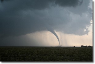
Weather Topic: What are Wall Clouds?
Home - Education - Cloud Types - Wall Clouds
 Next Topic: Altocumulus Clouds
A wall cloud forms underneath the base of a cumulonimbus cloud,
and can be a hotbed for deadly tornadoes.
Wall clouds are formed by air flowing into the cumulonimbus clouds, which can
result in the wall cloud descending from the base of the cumulonimbus cloud, or
rising fractus clouds which join to the base of the storm cloud as the wall cloud
takes shape.
Wall clouds can be very large, and in the Northern Hemisphere they generally
form at the southern edge of cumulonimbus clouds.
Next Topic: Altocumulus Clouds
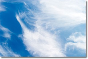
Weather Topic: What are Altostratus Clouds?
Home - Education - Cloud Types - Altostratus Clouds
 Next Topic: Cirrocumulus Clouds
Altostratus clouds form at mid to high-level altitudes
(between 2 and 7 km) and are created by a warm, stable air mass which causes
water vapor
to condense as it rise through the atmosphere. Usually altostratus clouds are
featureless sheets characterized by a uniform color.
In some cases, wind punching through the cloud formation may give it a waved
appearance, called altostratus undulatus. Altostratus clouds
are commonly seen with other cloud formations accompanying them.
Next Topic: Cirrocumulus Clouds
Current conditions powered by WeatherAPI.com


